Gauriac (Gauriac)

- commune in Gironde, France
- Country:

- Postal Code: 33710
- Coordinates: 45° 3' 51" N, 0° 37' 2" E


- GPS tracks (wikiloc): [Link]
- Area: 5.54 sq km
- Population: 769
- Web site: http://www.gauriac.fr
- Wikipedia en: wiki(en)
- Wikipedia: wiki(fr)
- Wikidata storage: Wikidata: Q185402
- Wikipedia Commons Category: [Link]
- Freebase ID: [/m/03nrzkq]
- GeoNames ID: Alt: [6432236]
- SIREN number: [213301823]
- BnF ID: [15256234j]
- WOEID: [592516]
- INSEE municipality code: 33182
Shares border with regions:

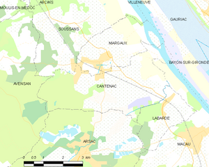
Cantenac
- former commune in Gironde, France
- Country:
- Postal Code: 33460
- Coordinates: 45° 1' 41" N, 0° 39' 13" E
- GPS tracks (wikiloc): [Link]
- Area: 14.26 sq km
- Population: 1364
- Web site: [Link]


Villeneuve
- commune in Gironde, France
- Country:
- Postal Code: 33710
- Coordinates: 45° 5' 1" N, 0° 37' 40" E
- GPS tracks (wikiloc): [Link]
- AboveSeaLevel: 5 м m
- Area: 4.63 sq km
- Population: 392


Soussans
- commune in Gironde, France
- Country:
- Postal Code: 33460
- Coordinates: 45° 3' 21" N, 0° 41' 57" E
- GPS tracks (wikiloc): [Link]
- Area: 13.55 sq km
- Population: 1601


Margaux
- former commune in Gironde, France
- Country:
- Postal Code: 33460
- Coordinates: 45° 2' 28" N, 0° 40' 36" E
- GPS tracks (wikiloc): [Link]
- Area: 7.36 sq km
- Population: 1541
- Web site: [Link]

Bayon-sur-Gironde
- commune in Gironde, France
- Country:
- Postal Code: 33710
- Coordinates: 45° 3' 15" N, 0° 36' 2" E
- GPS tracks (wikiloc): [Link]
- AboveSeaLevel: 47 м m
- Area: 5.7 sq km
- Population: 696


Saint-Ciers-de-Canesse
- commune in Gironde, France
- Country:
- Postal Code: 33710
- Coordinates: 45° 5' 1" N, 0° 36' 33" E
- GPS tracks (wikiloc): [Link]
- Area: 6.8 sq km
- Population: 807


Comps
- commune in Gironde, France
- Country:
- Postal Code: 33710
- Coordinates: 45° 4' 5" N, 0° 35' 43" E
- GPS tracks (wikiloc): [Link]
- Area: 1.66 sq km
- Population: 529