Genneteil (Genneteil)

- former commune in Maine-et-Loire, France
- Country:

- Postal Code: 49490
- Coordinates: 47° 35' 34" N, 0° 2' 57" E


- GPS tracks (wikiloc): [Link]
- Area: 35.95 sq km
- Population: 323
- Wikipedia en: wiki(en)
- Wikipedia: wiki(fr)
- Wikidata storage: Wikidata: Q1164110
- Wikipedia Commons Category: [Link]
- Freebase ID: [/m/03w9jj1]
- GeoNames ID: Alt: [3016326]
- BnF ID: [15261751h]
- INSEE municipality code: 49150
Shares border with regions:

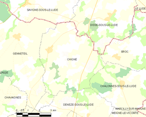
Chigné
- former commune in Maine-et-Loire, France
- Country:
- Postal Code: 49490
- Coordinates: 47° 35' 2" N, 0° 5' 14" E
- GPS tracks (wikiloc): [Link]
- Area: 25.22 sq km
- Population: 311
Auverse
- former commune in Maine-et-Loire, France
- Country:
- Postal Code: 49490
- Coordinates: 47° 31' 6" N, 0° 3' 4" E
- GPS tracks (wikiloc): [Link]
- Area: 30.74 sq km
- Population: 435


Savigné-sous-le-Lude
- commune in Sarthe, France
- Country:
- Postal Code: 72800
- Coordinates: 47° 37' 8" N, 0° 3' 28" E
- GPS tracks (wikiloc): [Link]
- Area: 33.84 sq km
- Population: 430

Lasse
- former commune in Maine-et-Loire, France
- Country:
- Postal Code: 49490
- Coordinates: 47° 32' 12" N, 0° 0' 39" E
- GPS tracks (wikiloc): [Link]
- Area: 28.94 sq km
- Population: 280
Chavaignes
- former commune in Maine-et-Loire, France
- Country:
- Postal Code: 49490
- Coordinates: 47° 32' 29" N, 0° 2' 13" E
- GPS tracks (wikiloc): [Link]
- Area: 7.42 sq km
- Population: 92