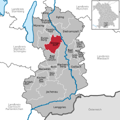
Geretsried (Geretsried)
- town in Bavaria, Germany
Geretsried, located in Bavaria, Germany, is a great spot for hiking enthusiasts due to its scenic natural surroundings and access to various trails. Nestled close to the foothills of the Alps, Geretsried offers a mix of easy walks and more challenging hikes, catering to different skill levels.
Hiking Trails
-
Local Trails: There are numerous trails around Geretsried that provide beautiful views and a chance to experience the local flora and fauna. The trails vary in distance and difficulty, making them suitable for families and serious hikers alike.
-
Isar River Path: The Isar River flows near Geretsried, and there are lovely paths that follow the river. These trails are generally flat and suitable for all skill levels, perfect for a leisurely hike or a bike ride.
-
Nearby Mountains: For those looking for more challenging hikes, the nearby Bavarian Alps provide excellent options. You can venture toward trails that lead to higher altitudes, offering splendid views of the Alps and surrounding areas.
Hiking Tips
-
Seasonal Considerations: The best times for hiking in Geretsried are spring through early fall. Be mindful of weather conditions, especially in winter when some trails may be inaccessible.
-
Gear: Ensure you wear proper hiking boots and bring sufficient water, snacks, and navigation aids, such as maps or GPS devices.
-
Local Guidance: Consider joining guided hiking tours if you are unfamiliar with the area. Local guides can enhance your experience by sharing knowledge about the region's natural history.
Attractions
-
Scenic Views: Many trails offer spectacular vistas of the rolling hills and distant mountains, ideal for photography and enjoying nature.
-
Cultural Sites: Combine your hiking experience with visits to local landmarks and cultural sites in Geretsried and surrounding areas.
Geretsried offers a lovely escape into nature and is a great starting point for exploring the beautiful Bavarian landscape. Whether you're a beginner or an experienced hiker, there's something for everyone!
- Country:

- Postal Code: 82538
- Local Dialing Code: 08171
- Coordinates: 47° 52' 0" N, 11° 28' 0" E


- GPS tracks (wikiloc): [Link]
- AboveSeaLevel: 605 м m
- Area: 24.65 sq km
- Population: 20722
- Web site: http://www.geretsried.de
- Wikipedia en: wiki(en)
- Wikipedia: wiki(de)
- Wikidata storage: Wikidata: Q504780
- Wikipedia Commons Category: [Link]
- Freebase ID: [/m/054jr_]
- GeoNames ID: Alt: [2921139]
- VIAF ID: Alt: [138411230]
- OSM relation ID: [935148]
- GND ID: Alt: [4020312-8]
- MusicBrainz area ID: [738ce850-43e1-4855-be35-2139e76c1e23]
- WOEID: [652217]
- Historical Gazetteer (GOV) ID: [object_301027]
- Bavarikon ID: [ODB_A00000957]
- German municipality key: 09173126
Shares border with regions:


Königsdorf
- municipality of Germany
Königsdorf is a picturesque village located in Bavaria, Germany, surrounded by beautiful natural landscapes that offer excellent hiking opportunities. The area is characterized by rolling hills, dense forests, and stunning views of the surrounding mountains, making it a great destination for both novice and experienced hikers....
- Country:

- Postal Code: 82549
- Local Dialing Code: 08046; 08171; 08179
- Coordinates: 47° 49' 0" N, 11° 29' 0" E


- GPS tracks (wikiloc): [Link]
- AboveSeaLevel: 625 м m
- Area: 45.69 sq km
- Population: 2988
- Web site: [Link]


Eurasburg
- human settlement in Germany
Eurasburg, located in Bavaria, Germany, is a charming destination for hiking enthusiasts. The region offers a mix of gentle hills and picturesque countryside, making it ideal for a variety of hiking experiences suitable for all skill levels. Here are some highlights of hiking in Eurasburg:...
- Country:

- Postal Code: 82547
- Local Dialing Code: 08179
- Coordinates: 47° 52' 0" N, 11° 24' 0" E


- GPS tracks (wikiloc): [Link]
- AboveSeaLevel: 600 м m
- Area: 40.9 sq km
- Population: 2894
- Web site: [Link]

