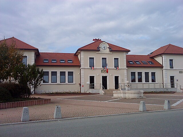
Gex (Gex)
- commune in Ain, France
Gex, located in the Ain department of the Auvergne-Rhône-Alpes region in France, offers a range of hiking opportunities that showcase the stunning natural beauty of the area, particularly due to its proximity to the Jura Mountains and the stunning views of Lake Geneva.
Trail Highlights
-
Sentier des Cimes: This trail offers spectacular views of the surrounding landscape, including both the Jura and the Alps. It's a great moderate hike and is well-marked.
-
La Dole: This is one of the more popular hiking destinations near Gex, leading to the summit of La Dole, which is just on the border with Switzerland. The hike rewards those who venture to the top with panoramic views of the Alps and Lake Geneva.
-
Les Crêts du Mont-Saxonnex: This area features various trails that go through beautiful forests and meadows, perfect for those looking for a peaceful walk surrounded by nature.
-
Jura Vaudois Nature Park: Just a short drive from Gex, this nature park has numerous marked trails, ranging from easy walks to more challenging hikes. It’s an excellent place to explore the diverse flora and fauna of the Jura region.
Hiking Tips
- Map and Navigation: Always carry a map or a GPS device, as some trails may not be well marked.
- Weather Conditions: The weather can change quickly in the mountains, so checking the forecast before heading out is essential.
- Clothing and Gear: Wear appropriate hiking boots and dress in layers, as temperatures can vary significantly with elevation changes.
- Water and Snacks: Always carry enough water and snacks, especially for longer hikes.
- Respect Nature: Stay on marked trails, and remember to pack out what you pack in to minimize your impact on the environment.
Accessibility
Gex is accessible by car, and there is public transportation available from larger cities nearby. The trails themselves range from family-friendly walks to more challenging hikes, making it suitable for all skill levels.
Conclusion
Hiking around Gex provides a wonderful opportunity to explore the beauty of the Jura Mountains and surrounding areas, whether you’re seeking a leisurely stroll or an adventurous trek. Always prepare adequately and enjoy the breathtaking landscapes!
- Country:

- Postal Code: 01170
- Coordinates: 46° 20' 0" N, 6° 3' 28" E


- GPS tracks (wikiloc): [Link]
- Area: 32.02 sq km
- Population: 11687
- Web site: http://www.gex.fr
- Wikipedia en: wiki(en)
- Wikipedia: wiki(fr)
- Wikidata storage: Wikidata: Q202451
- Wikipedia Commons Category: [Link]
- Wikipedia Commons Maps Category: [Link]
- Freebase ID: [/m/033lmv]
- Freebase ID: [/m/033lmv]
- GeoNames ID: Alt: [6424536]
- GeoNames ID: Alt: [6424536]
- SIREN number: [210101739]
- SIREN number: [210101739]
- VIAF ID: Alt: [236455706]
- VIAF ID: Alt: [236455706]
- Quora topic ID: [Gex-Ain]
- Quora topic ID: [Gex-Ain]
- Global Anabaptist Mennonite Encyclopedia Online ID: [Gex (Rhône-Alpes, France)]
- Global Anabaptist Mennonite Encyclopedia Online ID: [Gex (Rhône-Alpes, France)]
- INSEE municipality code: 01173
- INSEE municipality code: 01173
Shares border with regions:

Échenevex
- commune in Ain, France
Échenevex is a charming commune located in the Ain department in the Auvergne-Rhône-Alpes region of France. It’s known for its beautiful natural landscapes, making it a great destination for hiking enthusiasts. Here are some highlights and tips for hiking in Échenevex:...
- Country:

- Postal Code: 01170
- Coordinates: 46° 18' 32" N, 6° 2' 10" E


- GPS tracks (wikiloc): [Link]
- Area: 16.44 sq km
- Population: 2212
- Web site: [Link]

Mijoux
- commune in Ain, France
Mijoux is a charming commune located in the Jura region of France, known for its beautiful landscapes and outdoor activities, particularly hiking. Nestled near the Swiss border and surrounded by rolling hills, forests, and scenic views, Mijoux offers a great starting point for various hiking trails suitable for different skill levels. Here are some key points to consider when hiking in Mijoux:...
- Country:

- Postal Code: 01170
- Coordinates: 46° 21' 58" N, 5° 59' 43" E


- GPS tracks (wikiloc): [Link]
- Area: 22 sq km
- Population: 336
- Web site: [Link]

Cessy
- commune in Ain, France
Cessy is a charming commune located in the Ain department in the Auvergne-Rhône-Alpes region of France, near the border with Switzerland. It's quite close to the city of Geneva, making it an appealing destination for outdoor enthusiasts looking for both nature and proximity to urban amenities....
- Country:

- Postal Code: 01170
- Coordinates: 46° 19' 9" N, 6° 4' 12" E


- GPS tracks (wikiloc): [Link]
- AboveSeaLevel: 580 м m
- Area: 6.39 sq km
- Population: 4817
- Web site: [Link]

Vesancy
- commune in Ain, France
Vesancy, a picturesque village located in the Jura region of France, offers a charming backdrop for hikers and nature enthusiasts. Nestled among rolling hills, dense forests, and scenic landscapes, it serves as a starting point for a variety of hiking trails. Here are some highlights for hiking in and around Vesancy:...
- Country:

- Postal Code: 01170
- Coordinates: 46° 20' 55" N, 6° 5' 27" E


- GPS tracks (wikiloc): [Link]
- Area: 10.7 sq km
- Population: 502
- Web site: [Link]

Grilly
- commune in Ain, France
Grilly is a charming and scenic area in the French Alps, known for its beautiful landscapes and outdoor activities, including hiking. The region offers a variety of trails that cater to different skill levels, from leisurely walks to more challenging hikes....
- Country:

- Postal Code: 01220
- Coordinates: 46° 19' 50" N, 6° 6' 54" E


- GPS tracks (wikiloc): [Link]
- Area: 7.5 sq km
- Population: 792
- Web site: [Link]
