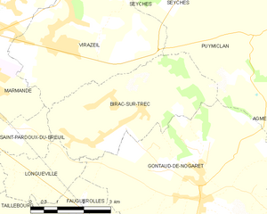
Gontaud-de-Nogaret (Gontaud-de-Nogaret)
- commune in Lot-et-Garonne, France
- Country:

- Postal Code: 47400
- Coordinates: 44° 27' 23" N, 0° 17' 42" E


- GPS tracks (wikiloc): [Link]
- AboveSeaLevel: 45 м m
- Area: 29.51 sq km
- Population: 1677
- Wikipedia en: wiki(en)
- Wikipedia: wiki(fr)
- Wikidata storage: Wikidata: Q218480
- Wikipedia Commons Category: [Link]
- Freebase ID: [/m/03qm1l5]
- GeoNames ID: Alt: [6616869]
- SIREN number: [214701104]
- BnF ID: [152611913]
- VIAF ID: Alt: [282316029]
- SUDOC authorities ID: [165710152]
- INSEE municipality code: 47110
Shares border with regions:
Agmé
- commune in Lot-et-Garonne, France
- Country:

- Postal Code: 47350
- Coordinates: 44° 29' 25" N, 0° 20' 46" E


- GPS tracks (wikiloc): [Link]
- Area: 5.01 sq km
- Population: 104


Fauillet
- commune in Lot-et-Garonne, France
- Country:

- Postal Code: 47400
- Coordinates: 44° 25' 33" N, 0° 17' 24" E


- GPS tracks (wikiloc): [Link]
- Area: 14.23 sq km
- Population: 839
- Web site: [Link]


Puymiclan
- commune in Lot-et-Garonne, France
- Country:

- Postal Code: 47350
- Coordinates: 44° 30' 44" N, 0° 18' 57" E


- GPS tracks (wikiloc): [Link]
- Area: 25.74 sq km
- Population: 636
Longueville
- commune in Lot-et-Garonne, France
- Country:

- Postal Code: 47200
- Coordinates: 44° 27' 42" N, 0° 12' 58" E


- GPS tracks (wikiloc): [Link]
- Area: 4.79 sq km
- Population: 355
Varès
- commune in Lot-et-Garonne, France
- Country:

- Postal Code: 47400
- Coordinates: 44° 25' 42" N, 0° 21' 20" E


- GPS tracks (wikiloc): [Link]
- Area: 16.79 sq km
- Population: 650


Birac-sur-Trec
- commune in Lot-et-Garonne, France
- Country:

- Postal Code: 47200
- Coordinates: 44° 29' 10" N, 0° 15' 53" E


- GPS tracks (wikiloc): [Link]
- Area: 14.34 sq km
- Population: 858


Fauguerolles
- commune in Lot-et-Garonne, France
- Country:

- Postal Code: 47400
- Coordinates: 44° 26' 26" N, 0° 14' 57" E


- GPS tracks (wikiloc): [Link]
- Area: 6.93 sq km
- Population: 776
Hautesvignes
- commune in Lot-et-Garonne, France
- Country:

- Postal Code: 47400
- Coordinates: 44° 27' 33" N, 0° 21' 8" E


- GPS tracks (wikiloc): [Link]
- Area: 8.85 sq km
- Population: 168
