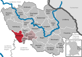
Gotteszell (Gotteszell)

- municipality of Germany
 Hiking in Gotteszell
Gotteszell, located in the Bavarian Forest of Germany, is a charming destination for hiking enthusiasts. The area is characterized by its lush forests, rolling hills, and stunning panoramic views, making it ideal for outdoor activities. Here’s a brief overview of what to expect while hiking in Gotteszell:
Trails
-
Well-Marked Trails: There are numerous well-marked hiking trails ranging from easy walks suitable for families to more challenging routes for experienced hikers. Trails are often marked with color-coded signs, making navigation easier.
-
Scenic Routes: One of the highlights of hiking in Gotteszell is the scenic views. Many trails offer great vantage points overlooking the surrounding forested landscapes and valleys.
-
Nature Reserves: The area is surrounded by natural parks, such as the Bavarian Forest National Park, where hikers can enjoy rich biodiversity and possibly spot local wildlife, including deer and various bird species.
Tips for Hiking in Gotteszell
-
Weather Preparedness: The weather can change quickly in mountainous regions, so be prepared with appropriate gear, including rain jackets and layered clothing.
-
Local Map: Although trails are marked, having a local hiking map or GPS can be helpful, especially for those planning to venture off the beaten path.
-
Stay Hydrated: Bring enough water and snacks, as some trails may not have access to rest areas or shops along the way.
-
Respect Nature: Follow the Leave No Trace principles to help preserve the natural beauty of the area.
Conclusion
Hiking in Gotteszell offers a tranquil escape into nature with a variety of trails for all skill levels. It’s an excellent choice for both casual walkers and more hardcore adventurers looking to explore the beautiful Bavarian Forest region. Always be sure to check local resources or visitor centers for any updates on trail conditions and additional information. Happy hiking!
- Country:

- Postal Code: 94239
- Local Dialing Code: 09929
- Licence Plate Code: REG
- Coordinates: 48° 58' 0" N, 12° 58' 0" E


- GPS tracks (wikiloc): [Link]
- AboveSeaLevel: 510 м m
- Area: 9.22 sq km
- Population: 1167
- Web site: http://www.gotteszell.de
- Wikipedia en: wiki(en)
- Wikipedia: wiki(de)
- Wikidata storage: Wikidata: Q489005
- Wikipedia Commons Category: [Link]
- Freebase ID: [/m/02q78pm]
- GeoNames ID: Alt: [2918661]
- OSM relation ID: [959169]
- GND ID: Alt: [4238447-3]
- archINFORM location ID: [13266]
- Historical Gazetteer (GOV) ID: [GOTEL1JN68LX]
- Bavarikon ID: [ODB_A00001594]
- German municipality key: 09276123
Shares border with regions:

Bernried
- municipality of Germany
Hiking in Bernried
Bernried, located in Bavaria, Germany, is an excellent destination for hiking enthusiasts. Nestled near the beautiful Starnberger See (Lake Starnberg), it offers a mix of picturesque landscapes, serene lakeshores, and forested hills. Here are some highlights to consider when hiking in Bernried:...
- Country:
- Postal Code: 94374; 94505
- Local Dialing Code: 09905
- Licence Plate Code: DEG
- Coordinates: 48° 55' 0" N, 12° 52' 0" E
- GPS tracks (wikiloc): [Link]
- AboveSeaLevel: 382 м m
- Area: 39.47 sq km
- Population: 4772
- Web site: [Link]

Achslach
- municipality of Germany
Hiking in Achslach
Achslach is a beautiful area located in Bavaria, Germany, known for its stunning natural landscapes, dense forests, and scenic hiking trails. Here are some highlights and tips for hiking in and around Achslach:...
- Country:
- Postal Code: 94250
- Local Dialing Code: 09929
- Licence Plate Code: REG
- Coordinates: 48° 58' 18" N, 12° 56' 6" E
- GPS tracks (wikiloc): [Link]
- AboveSeaLevel: 595 м m
- Area: 30.05 sq km
- Population: 1083
- Web site: [Link]


Ruhmannsfelden
- municipality of Germany
Hiking in Ruhmannsfelden
Ruhmannsfelden, a picturesque town in Bavaria, Germany, offers an array of scenic hiking opportunities for outdoor enthusiasts. Nestled in the heart of the Bavarian Forest, the region is characterized by its beautiful landscapes, lush forests, and rolling hills. Here’s what you can expect when hiking in and around Ruhmannsfelden:...
- Country:
- Postal Code: 94239
- Local Dialing Code: 09929
- Licence Plate Code: REG
- Coordinates: 48° 59' 0" N, 12° 59' 0" E
- GPS tracks (wikiloc): [Link]
- AboveSeaLevel: 536 м m
- Area: 5.8 sq km
- Population: 1972
- Web site: [Link]

Grafling
- municipality of Germany
Hiking in Grafling
Hiking in Grafling, located in Bavaria, Germany, offers a variety of scenic trails and beautiful landscapes, making it an excellent destination for outdoor enthusiasts. Here are some highlights and tips for hiking in the area:...
- Country:
- Postal Code: 94539
- Local Dialing Code: 0991
- Licence Plate Code: DEG
- Coordinates: 48° 53' 40" N, 12° 58' 30" E
- GPS tracks (wikiloc): [Link]
- AboveSeaLevel: 433 м m
- Area: 46.32 sq km
- Population: 2738
- Web site: [Link]