Hecmanville (Hecmanville)

- commune in Eure, France
- Country:

- Postal Code: 27800
- Coordinates: 49° 10' 26" N, 0° 39' 36" E


- GPS tracks (wikiloc): [Link]
- Area: 2.99 sq km
- Population: 170
- Wikipedia en: wiki(en)
- Wikipedia: wiki(fr)
- Wikidata storage: Wikidata: Q629803
- Wikipedia Commons Category: [Link]
- Freebase ID: [/m/03nqjt2]
- Freebase ID: [/m/03nqjt2]
- GeoNames ID: Alt: [3013603]
- GeoNames ID: Alt: [3013603]
- SIREN number: [212703250]
- SIREN number: [212703250]
- BnF ID: [15253561j]
- BnF ID: [15253561j]
- PACTOLS thesaurus ID: [pcrt2Y4T6V4YlJ]
- PACTOLS thesaurus ID: [pcrt2Y4T6V4YlJ]
- INSEE municipality code: 27325
- INSEE municipality code: 27325
Shares border with regions:


Franqueville
- commune in Eure, France
- Country:
- Postal Code: 27800
- Coordinates: 49° 10' 30" N, 0° 41' 24" E
- GPS tracks (wikiloc): [Link]
- Area: 3.03 sq km
- Population: 337


Berthouville
- commune in Eure, France
- Country:
- Postal Code: 27800
- Coordinates: 49° 10' 46" N, 0° 38' 5" E
- GPS tracks (wikiloc): [Link]
- Area: 7.53 sq km
- Population: 306


Boisney
- commune in Eure, France
- Country:
- Postal Code: 27800
- Coordinates: 49° 9' 16" N, 0° 39' 18" E
- GPS tracks (wikiloc): [Link]
- Area: 5.76 sq km
- Population: 287

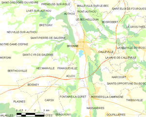
Brionne
- commune in Eure, France
- Country:
- Postal Code: 27800
- Coordinates: 49° 11' 41" N, 0° 43' 13" E
- GPS tracks (wikiloc): [Link]
- Area: 16.77 sq km
- Population: 4326
- Web site: [Link]