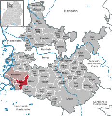
Hockenheim (Hockenheim)

- German town in northwest Baden-Württemberg
 Hiking in Hockenheim
Hockenheim, located in Germany, is known primarily for its motorsport, particularly the Hockenheimring racetrack. However, the surrounding region offers plenty of opportunities for hiking and enjoying outdoor activities. Here are some details about hiking in and around Hockenheim:
Hiking Trails
-
Rhein-Neckar Region: Hockenheim is situated in the Rhein-Neckar area, which has various hiking trails. You can explore scenic paths that take you through vineyards, forests, and along the Rhine River.
-
Hockenheim Forest (Hockenheimer Wald): This forested area near the town provides several trails. It's a great spot for walking, running, or enjoying nature. You can find well-marked paths suitable for different skill levels.
-
Rhein River Paths: Walking along the Rhine River offers picturesque views and a peaceful atmosphere. There are numerous pathways alongside the river, perfect for leisurely hikes or cycling.
Popular Hiking Areas Nearby
-
Odenwald: A bit further away, the Odenwald offers more challenging hikes with beautiful landscapes. Trails in the Odenwald, such as the Nibelungensteig, provide stunning views and the chance to explore regional flora and fauna.
-
Palatinate Forest: Located southwest of Hockenheim, this UNESCO Biosphere Reserve features extensive hiking trails through a large forest area, including routes that range from easy strolls to more challenging hikes.
Tips for Hiking in Hockenheim
- Weather Prep: Always check the weather forecast before heading out, as conditions can change quickly.
- Footwear: Wear appropriate hiking shoes for comfort and support, especially on uneven terrain.
- Hydration and Snacks: Carry enough water and snacks to keep your energy up during your hike.
- Maps and Navigation: Consider bringing a map or downloading a hiking app to navigate trails easily.
- Respect Nature: Follow Leave No Trace principles to keep the environment clean and safe for everyone.
Local Attractions
In addition to hiking, consider visiting the Hockenheimring for motorsport events or exploring local museums and restaurants in Hockenheim for a taste of regional culture.
Hiking in and around Hockenheim can be a wonderful experience, combining natural beauty with the charm of the German countryside. Enjoy your adventures!
- Country:

- Postal Code: 68766
- Local Dialing Code: 06205
- Licence Plate Code: HD
- Coordinates: 49° 19' 5" N, 8° 32' 50" E


- GPS tracks (wikiloc): [Link]
- AboveSeaLevel: 102 м m
- Area: 34.84 sq km
- Population: 21011
- Web site: http://www.hockenheim.de
- Wikipedia en: wiki(en)
- Wikipedia: wiki(de)
- Wikidata storage: Wikidata: Q8336
- Wikipedia Commons Category: [Link]
- Freebase ID: [/m/04x2r6]
- GeoNames ID: Alt: [2902852]
- VIAF ID: Alt: [157120108]
- OSM relation ID: [453413]
- GND ID: Alt: [4025299-1]
- archINFORM location ID: [146]
- Library of Congress authority ID: Alt: [n81127889]
- WOEID: [660659]
- Quora topic ID: [Hockenheim]
- German municipality key: 08226032
Shares border with regions:


Oftersheim
- municipality in Germany
Hiking in Oftersheim
Oftersheim is a small town located in the state of Baden-Württemberg, Germany, and is situated near the larger cities of Heidelberg and Mannheim. While it may not be a major hiking destination by itself, its proximity to various natural areas and parks offers opportunities for outdoor excursions. Here are some highlights and tips for hiking around Oftersheim:...
- Country:
- Postal Code: 68723
- Local Dialing Code: 06202
- Licence Plate Code: HD
- Coordinates: 49° 21' 55" N, 8° 34' 59" E
- GPS tracks (wikiloc): [Link]
- AboveSeaLevel: 103 м m
- Area: 12.78 sq km
- Population: 11878
- Web site: [Link]

Reilingen
- municipality in Germany
Hiking in Reilingen
Reilingen is a small municipality located in the state of Baden-Württemberg, Germany. It is situated near the Rhine River and surrounded by beautiful countryside, which makes it a great spot for hiking enthusiasts. Here are some key points about hiking in and around Reilingen:...
- Country:
- Postal Code: 68799
- Local Dialing Code: 06205
- Licence Plate Code: HD
- Coordinates: 49° 17' 54" N, 8° 33' 51" E
- GPS tracks (wikiloc): [Link]
- AboveSeaLevel: 102 м m
- Area: 16.35 sq km
- Population: 7574
- Web site: [Link]