Igoville (Igoville)

- commune in Eure, France
- Country:

- Postal Code: 27460
- Coordinates: 49° 19' 10" N, 1° 8' 58" E


- GPS tracks (wikiloc): [Link]
- Area: 5.61 sq km
- Population: 1720
- Web site: http://www.ville-igoville.com
- Wikipedia en: wiki(en)
- Wikipedia: wiki(fr)
- Wikidata storage: Wikidata: Q1073417
- Wikipedia Commons Category: [Link]
- Freebase ID: [/m/03nqk09]
- Freebase ID: [/m/03nqk09]
- GeoNames ID: Alt: [6430448]
- GeoNames ID: Alt: [6430448]
- SIREN number: [212703482]
- SIREN number: [212703482]
- BnF ID: [152535846]
- BnF ID: [152535846]
- PACTOLS thesaurus ID: [pcrtlPFz7Ao1P5]
- PACTOLS thesaurus ID: [pcrtlPFz7Ao1P5]
- INSEE municipality code: 27348
- INSEE municipality code: 27348
Shares border with regions:


Alizay
- commune in Eure, France
- Country:
- Postal Code: 27460
- Coordinates: 49° 19' 15" N, 1° 10' 32" E
- GPS tracks (wikiloc): [Link]
- Area: 8.62 sq km
- Population: 1476
Sotteville-sous-le-Val
- commune in Seine-Maritime, France
- Country:
- Postal Code: 76410
- Coordinates: 49° 19' 14" N, 1° 7' 30" E
- GPS tracks (wikiloc): [Link]
- Area: 5.27 sq km
- Population: 801

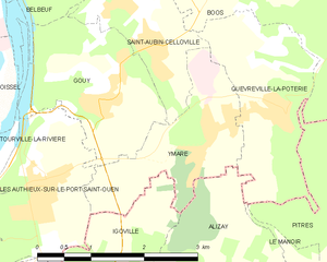
Ymare
- commune in Seine-Maritime, France
- Country:
- Postal Code: 76520
- Coordinates: 49° 20' 57" N, 1° 10' 32" E
- GPS tracks (wikiloc): [Link]
- Area: 4.03 sq km
- Population: 1162
- Web site: [Link]

Pont-de-l'Arche
- commune in Eure, France
- Country:
- Postal Code: 27340
- Coordinates: 49° 18' 10" N, 1° 9' 14" E
- GPS tracks (wikiloc): [Link]
- Area: 9.35 sq km
- Population: 4166
- Web site: [Link]


Les Authieux-sur-le-Port-Saint-Ouen
- commune in Seine-Maritime, France
- Country:
- Postal Code: 76520
- Coordinates: 49° 20' 25" N, 1° 8' 1" E
- GPS tracks (wikiloc): [Link]
- AboveSeaLevel: 75 м m
- Area: 4.53 sq km
- Population: 1244
- Web site: [Link]