Irodouër (Irodouër)

- commune in Ille-et-Vilaine, France
- Country:

- Postal Code: 35850
- Coordinates: 48° 14' 59" N, 1° 57' 3" E


- GPS tracks (wikiloc): [Link]
- Area: 23.54 sq km
- Population: 2231
- Web site: http://www.mairie-irodouer.fr
- Wikipedia en: wiki(en)
- Wikipedia: wiki(fr)
- Wikidata storage: Wikidata: Q196478
- Wikipedia Commons Category: [Link]
- Freebase ID: [/m/03mbbx0]
- Freebase ID: [/m/03mbbx0]
- Freebase ID: [/m/03mbbx0]
- GeoNames ID: Alt: [6432715]
- GeoNames ID: Alt: [6432715]
- GeoNames ID: Alt: [6432715]
- SIREN number: [213501356]
- SIREN number: [213501356]
- SIREN number: [213501356]
- BnF ID: [152570796]
- BnF ID: [152570796]
- BnF ID: [152570796]
- OSM relation ID: [912435]
- OSM relation ID: [912435]
- OSM relation ID: [912435]
- PACTOLS thesaurus ID: [pcrtK8c0TxgAlp]
- PACTOLS thesaurus ID: [pcrtK8c0TxgAlp]
- PACTOLS thesaurus ID: [pcrtK8c0TxgAlp]
- MusicBrainz area ID: [5b427a2e-a70b-408c-90a9-92982587d7db]
- MusicBrainz area ID: [5b427a2e-a70b-408c-90a9-92982587d7db]
- MusicBrainz area ID: [5b427a2e-a70b-408c-90a9-92982587d7db]
- INSEE municipality code: 35135
- INSEE municipality code: 35135
- INSEE municipality code: 35135
Shares border with regions:

Landujan
- commune in Ille-et-Vilaine, France
- Country:
- Postal Code: 35360
- Coordinates: 48° 15' 1" N, 1° 59' 47" E
- GPS tracks (wikiloc): [Link]
- Area: 14.32 sq km
- Population: 981

Bédée
- commune in Ille-et-Vilaine, France
- Country:
- Postal Code: 35137
- Coordinates: 48° 10' 46" N, 1° 56' 39" E
- GPS tracks (wikiloc): [Link]
- Area: 38.95 sq km
- Population: 4200
- Web site: [Link]


Miniac-sous-Bécherel
- commune in Ille-et-Vilaine, France
- Country:
- Postal Code: 35190
- Coordinates: 48° 17' 7" N, 1° 55' 56" E
- GPS tracks (wikiloc): [Link]
- Area: 13.55 sq km
- Population: 755
- Web site: [Link]

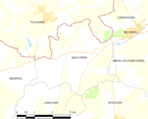
Saint-Pern
- commune in Ille-et-Vilaine, France
- Country:
- Postal Code: 35190
- Coordinates: 48° 17' 16" N, 1° 59' 12" E
- GPS tracks (wikiloc): [Link]
- Area: 12.13 sq km
- Population: 1018


Romillé
- commune in Ille-et-Vilaine, France
- Country:
- Postal Code: 35850
- Coordinates: 48° 12' 57" N, 1° 53' 31" E
- GPS tracks (wikiloc): [Link]
- Area: 28.67 sq km
- Population: 3878
- Web site: [Link]


La Chapelle-du-Lou
- former commune in Ille-et-Vilaine, France
- Country:
- Postal Code: 35360
- Coordinates: 48° 12' 46" N, 1° 59' 32" E
- GPS tracks (wikiloc): [Link]
- Area: 7.28 sq km
- Population: 895