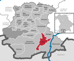
Krün (Krün)
- municipality of Germany
Krün is a charming village located in Bavaria, Germany, surrounded by the stunning landscapes of the Alps. It serves as a fantastic base for hiking enthusiasts, offering a variety of trails that cater to different skill levels and preferences.
Hiking Trails in Krün:
-
Kühbodener Alm: This popular trail leads to the Kühbodener Alm and provides beautiful views of the surrounding mountains. The hike is moderately difficult and takes about 1.5 to 2 hours each way.
-
Isar River Trail: A more leisurely option, this trail follows the picturesque Isar River. It's perfect for families and those who prefer a gentler hike, with opportunities for picnicking by the riverbanks.
-
Fern Pass: For more experienced hikers, the Fern Pass trail offers stunning panoramic views and a chance to experience the rugged beauty of the mountains. This trail is longer and more difficult, so it’s best suited for those with a good level of fitness.
-
Zugspitze: Although a bit farther from Krün, an excursion to Zugspitze, Germany’s highest peak, is worth considering. There are various trails leading up to the peak or you can take the cable car for a more leisurely experience.
-
Hiking to Lautersee and Ferchensee: This route takes you to two beautiful mountain lakes, offering serene views and ideal spots for a relaxing break. The round trip usually takes around 3 to 4 hours.
General Tips for Hiking in Krün:
- Weather: Always check the weather conditions before heading out. Mountain weather can change rapidly.
- Gear: Wear proper hiking boots and dress in layers to adapt to changing temperatures. Don't forget essentials like water, snacks, and a first aid kit.
- Maps and Guides: Having a map or a hiking app can be very helpful. Some trails may not be well-marked.
- Wildlife: Be respectful of the local flora and fauna. It’s common to encounter various wildlife in the area, including deer and various bird species.
- Safety: Always let someone know your hiking plans, and if you’re venturing into more challenging terrain, consider going with a friend or a group.
Accessibility:
Krün is accessible via public transport, and there are several local facilities, including guesthouses and restaurants, that cater to hikers.
Whether you are looking for a short nature walk or a challenging mountain hike, Krün offers an array of options to suit all hikers. Enjoy your adventure in this beautiful part of Bavaria!
- Country:

- Postal Code: 82493; 82467; 82494
- Local Dialing Code: 08825
- Licence Plate Code: GAP
- Coordinates: 47° 30' 0" N, 11° 17' 0" E


- GPS tracks (wikiloc): [Link]
- AboveSeaLevel: 875 м m
- Area: 36.31 sq km
- Population: 1745
- Web site: http://www.kruen.de
- Wikipedia en: wiki(en)
- Wikipedia: wiki(de)
- Wikidata storage: Wikidata: Q509557
- Wikipedia Commons Category: [Link]
- Freebase ID: [/m/02q39bz]
- GeoNames ID: Alt: [6556242]
- VIAF ID: Alt: [237691989]
- OSM relation ID: [939340]
- GND ID: Alt: [4033298-6]
- archINFORM location ID: [16015]
- MusicBrainz area ID: [2f233d26-662d-424a-b22c-2848de4e3ab0]
- WOEID: [669238]
- Historical Gazetteer (GOV) ID: [object_300695]
- Bavarikon ID: [ODB_A00001126]
- German municipality key: 09180122
Shares border with regions:


Mittenwald
- town in Bavaria, Germany
Mittenwald, located in Bavaria, Germany, is a beautiful destination for hiking enthusiasts. Nestled in the Karwendel Mountain range, it offers a variety of trails that cater to all levels of hikers, from beginners to seasoned adventurers. Here are some highlights about hiking in the area:...
- Country:

- Postal Code: 82481
- Local Dialing Code: 08823
- Licence Plate Code: GAP
- Coordinates: 47° 25' 0" N, 11° 15' 0" E


- GPS tracks (wikiloc): [Link]
- AboveSeaLevel: 923 м m
- Area: 132.85 sq km
- Population: 7387
- Web site: [Link]

