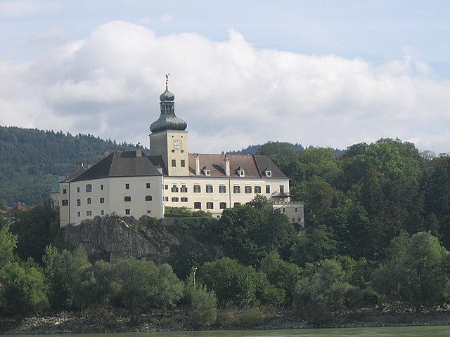
Krummnußbaum (Krummnußbaum)
- municipality in Austria
 Hiking in Krummnußbaum
Krummnußbaum is a picturesque area in Austria, situated near the Danube River, which offers a variety of hiking opportunities. Here are some highlights and tips for hiking in and around Krummnußbaum:
Scenic Trails
- Danube Trail: One of the most popular routes is the Danube Trail (Donauradweg), which runs along the river and offers stunning views. The trail is well-marked and suitable for hikers of all levels.
- Local Nature Trails: There are several smaller trails that lead through vineyards, forests, and hills, providing a chance to experience the natural beauty of the region.
Hiking Tips
- Wear Appropriate Footwear: Good hiking boots are essential, especially if you plan to tackle uneven terrain.
- Check the Weather: The weather can change quickly, so it's advisable to check forecasts and be prepared for varying conditions.
- Stay Hydrated: Bring plenty of water, especially on warm days, as some trails may not have easy access to water sources.
- Pack Snacks: Energy-rich snacks can keep you fueled as you explore the area.
Points of Interest
- Cultural Sights: Consider adding some cultural stops, such as local wineries or historic sites like the Melk Abbey nearby.
- Wildlife Viewing: Keep an eye out for local wildlife, including various bird species and other fauna that inhabit the region.
Accessibility
- Trail Difficulty: Most trails around Krummnußbaum are moderate, making them suitable for families and casual hikers. Always check trail difficulty ratings if you're planning to hike with children or less experienced hikers.
Safety Considerations
- Inform Someone of Your Plans: Let someone know your hiking route and estimated return time.
- Mobile Coverage: While the area is popular with hikers, some spots may have limited mobile service. Make sure to download maps or have a GPS device when hiking in unfamiliar territory.
In summary, hiking in Krummnußbaum offers a delightful mix of scenic views, cultural experiences, and outdoor adventure. Whether you're looking for a leisurely stroll along the Danube or a more challenging hike through the hills, you're likely to enjoy the beauty of this charming Austrian location.
- Country:

- Postal Code: 3375
- Local Dialing Code: 02757
- Licence Plate Code: ME
- Coordinates: 48° 12' 27" N, 15° 9' 53" E


- GPS tracks (wikiloc): [Link]
- AboveSeaLevel: 219 м m
- Area: 10.07 sq km
- Population: 1500
- Web site: http://www.krummnussbaum.at
- Wikipedia en: wiki(en)
- Wikipedia: wiki(de)
- Wikidata storage: Wikidata: Q671938
- Wikipedia Commons Category: [Link]
- Freebase ID: [/m/02qycfh]
- GeoNames ID: Alt: [2773325]
- VIAF ID: Alt: [235247117]
- Austrian municipality key: [31517]
Shares border with regions:

Pöchlarn
- municipality in Austria
Hiking in Pöchlarn
Pöchlarn, located in Lower Austria along the banks of the Danube River, offers a picturesque setting for hiking enthusiasts. The region is characterized by its scenic landscapes, including rolling hills, dense forests, and riverside trails. Here are some key points to consider if you're thinking about hiking in and around Pöchlarn:...
- Country:
- Postal Code: 3380
- Local Dialing Code: 02757
- Licence Plate Code: ME
- Coordinates: 48° 12' 0" N, 15° 12' 0" E
- GPS tracks (wikiloc): [Link]
- AboveSeaLevel: 216 м m
- Area: 17.92 sq km
- Population: 3912
- Web site: [Link]

Ybbs an der Donau
- municipality in Austria
Hiking in Ybbs an der Donau
Ybbs an der Donau is a charming town situated in Lower Austria, nestled along the banks of the Danube River. It offers a variety of hiking opportunities that cater to different skill levels, with scenic views, lush landscapes, and rich cultural experiences. Here are some highlights and tips for hiking in Ybbs:...
- Country:
- Postal Code: 3370
- Local Dialing Code: 07412
- Licence Plate Code: ME
- Coordinates: 48° 10' 0" N, 15° 4' 0" E
- GPS tracks (wikiloc): [Link]
- AboveSeaLevel: 224 м m
- Area: 23.82 sq km
- Population: 5653
- Web site: [Link]
Persenbeug-Gottsdorf
- municipality in Austria
Hiking in Persenbeug-Gottsdorf
Persenbeug-Gottsdorf is a charming area located in Austria, known for its picturesque landscapes and variety of outdoor activities, including hiking. Nestled along the Danube River, this region offers stunning views of the surrounding hills, forests, and water landscapes. Here are some key points about hiking in Persenbeug-Gottsdorf:...
- Country:
- Postal Code: 3680
- Local Dialing Code: 07412
- Licence Plate Code: ME
- Coordinates: 48° 10' 0" N, 15° 4' 0" E
- GPS tracks (wikiloc): [Link]
- AboveSeaLevel: 230 м m
- Area: 8.32 sq km
- Population: 2201
- Web site: [Link]
Bergland
- municipality in Austria
Hiking in Bergland
Bergland, Austria, is a beautiful region that offers a fantastic hiking experience, characterized by its stunning alpine landscapes, lush valleys, and charming villages. Here are some highlights and tips for hiking in Bergland:...
- Country:
- Postal Code: 3254
- Local Dialing Code: 07416
- Licence Plate Code: ME
- Coordinates: 48° 9' 20" N, 15° 10' 56" E
- GPS tracks (wikiloc): [Link]
- AboveSeaLevel: 252 м m
- Area: 33.89 sq km
- Population: 1909
- Web site: [Link]
Golling an der Erlauf
- municipality in Austria
Hiking in Golling an der Erlauf
Golling an der Erlauf is a beautiful area located in the Austrian state of Salzburg, known for its stunning landscapes, picturesque nature, and a variety of hiking trails suitable for different skill levels....
- Country:
- Postal Code: 3381
- Local Dialing Code: 02757
- Licence Plate Code: ME
- Coordinates: 48° 12' 0" N, 15° 11' 0" E
- GPS tracks (wikiloc): [Link]
- AboveSeaLevel: 215 м m
- Area: 2.71 sq km
- Population: 1514
- Web site: [Link]


Erlauf
- municipality in Austria
Hiking in Erlauf
Erlauf is a picturesque region located in Austria, offering beautiful landscapes and a variety of hiking opportunities for outdoor enthusiasts. The area is particularly known for its diverse terrain, including forests, mountains, and serene lakes, making it ideal for hikers of all skill levels....
- Country:
- Postal Code: 3253
- Local Dialing Code: 02757
- Licence Plate Code: ME
- Coordinates: 48° 11' 2" N, 15° 11' 3" E
- GPS tracks (wikiloc): [Link]
- AboveSeaLevel: 225 м m
- Area: 9.67 sq km
- Population: 1069
- Web site: [Link]


Marbach an der Donau
- municipality in Austria
Hiking in Marbach an der Donau
Marbach an der Donau is a charming village located along the Danube River in Austria, known for its picturesque landscapes and outdoor activities, including hiking. The area is surrounded by lush forests, rolling hills, and stunning views of the river, making it a great destination for nature enthusiasts....
- Country:
- Postal Code: 3671
- Local Dialing Code: 07413
- Licence Plate Code: ME
- Coordinates: 48° 13' 0" N, 15° 9' 0" E
- GPS tracks (wikiloc): [Link]
- AboveSeaLevel: 219 м m
- Area: 10.66 sq km
- Population: 1677
- Web site: [Link]