L'Épine (L'Épine)

- commune in Hautes-Alpes, France
 Hiking in L'Épine
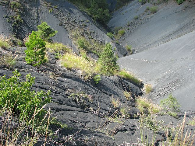
L'Épine, located in the Hautes-Alpes region of southeastern France, is known for its stunning natural beauty and a variety of hiking trails that cater to different skill levels. The area is characterized by picturesque landscapes, mountain ranges, valleys, and lakes. Here are some key points about hiking in L'Épine and its surroundings:
Trails and Routes
-
Diverse Terrain: The region offers a mix of trails, from easy walks suitable for families to challenging routes for experienced hikers. You can expect rocky paths, forest trails, and some sections with steeper ascents.
-
Scenic Views: Many trails offer breathtaking views of the surrounding mountains and valleys, including the Écrins National Park nearby. Look out for panoramic viewpoints where you can take in the stunning alpine scenery.
-
Local Flora and Fauna: Hiking in this area gives you a chance to see diverse plant life and wildlife. Keep an eye out for local species of birds, marmots, and ibex.
-
Popular Hiking Routes: Some recommended hikes near L'Épine include routes that lead to nearby mountain lakes and peaks. Researching or consulting with local guides can help you find the best routes based on your ability and interests.
Preparation and Safety
-
Weather: The weather in the Hautes-Alpes can change rapidly, so it's essential to check forecasts before heading out. Be prepared for varying conditions, especially at higher altitudes.
-
Gear: Wear appropriate footwear and clothing. Good hiking boots and layers that can be adjusted based on temperature are advisable. Don't forget essentials like water, snacks, a map, a compass, and a first-aid kit.
-
Navigation: While many trails are well-marked, it’s a good idea to bring a map and be familiar with the area, especially if you're trekking in less frequented zones.
-
Local Regulations: Respect local guidelines for hiking, such as sticking to marked trails and observing wildlife. It's also a good practice to follow Leave No Trace principles to preserve the natural environment.
Best Times to Hike
- Summer (June to September): This is the most popular time for hiking, with clear trails and warmer weather.
- Autumn (October): Offers beautiful fall foliage and fewer crowds, making it a lovely time for hikes with cooler temperatures.
- Winter: Some trails may be suitable for snowshoeing or winter hiking, but require different preparation and gear.
Accessibility
L'Épine is accessible by road, and there are various accommodations, from campsites to guesthouses. It’s a good idea to plan your stay in advance, especially during peak hiking seasons.
Whether you're an experienced hiker or a beginner looking to explore the beauty of the French Alps, L'Épine offers an excellent base for outdoor adventures. Enjoy your hiking experience!
- Country:

- Postal Code: 05700
- Coordinates: 44° 25' 1" N, 5° 37' 1" E


- GPS tracks (wikiloc): [Link]
- Area: 33.47 sq km
- Population: 192
- Wikipedia en: wiki(en)
- Wikipedia: wiki(fr)
- Wikidata storage: Wikidata: Q1087784
- Wikipedia Commons Category: [Link]
- Freebase ID: [/m/03m818y]
- Freebase ID: [/m/03m818y]
- GeoNames ID: Alt: [6618136]
- GeoNames ID: Alt: [6618136]
- SIREN number: [210500484]
- SIREN number: [210500484]
- VIAF ID: Alt: [1522152200735714400002]
- VIAF ID: Alt: [1522152200735714400002]
- INSEE municipality code: 05048
- INSEE municipality code: 05048
Shares border with regions:
Sorbiers
- commune in Hautes-Alpes, France
Hiking in Sorbiers
Hiking in Sorbiers, located in the Hautes-Alpes region of France, offers a delightful experience for outdoor enthusiasts. This area is characterized by its stunning alpine scenery, diverse ecosystems, and a variety of trails suitable for hikers of all levels....
- Country:
- Postal Code: 05150
- Coordinates: 44° 22' 29" N, 5° 33' 47" E
- GPS tracks (wikiloc): [Link]
- Area: 13.93 sq km
- Population: 38


Valdrôme
- commune in Drôme, France
Hiking in Valdrôme
Valdrôme is a picturesque village located in the Drôme department of the Auvergne-Rhône-Alpes region in southeastern France. It's known for its stunning natural scenery, which makes it a fantastic destination for hiking enthusiasts. Here are some details you might find helpful for planning a hiking trip there:...
- Country:
- Postal Code: 26310
- Coordinates: 44° 30' 15" N, 5° 34' 23" E
- GPS tracks (wikiloc): [Link]
- Area: 41.51 sq km
- Population: 147

Sigottier
- commune in Hautes-Alpes, France
Hiking in Sigottier
Sigottier is a charming commune located in the French Alps, specifically in the Hautes-Alpes department. The area is renowned for its stunning natural landscapes, offering a variety of hiking opportunities for outdoor enthusiasts. Here are some highlights for hiking in and around Sigottier:...
- Country:
- Postal Code: 05700
- Coordinates: 44° 27' 18" N, 5° 41' 31" E
- GPS tracks (wikiloc): [Link]
- Area: 25.33 sq km
- Population: 87

Ribeyret
- commune in Hautes-Alpes, France
Hiking in Ribeyret
Ribeyret is a picturesque village located in the Hautes-Alpes department of the Provence-Alpes-Côte d'Azur region in southeastern France. The area around Ribeyret is known for its stunning landscapes, diverse flora and fauna, and great opportunities for hiking and outdoor activities....
- Country:
- Postal Code: 05150
- Coordinates: 44° 24' 48" N, 5° 33' 17" E
- GPS tracks (wikiloc): [Link]
- Area: 17.87 sq km
- Population: 105
Montmorin
- former commune in Hautes-Alpes, France
Hiking in Montmorin
Montmorin, located in the Hautes-Alpes region of France, is a stunning area for outdoor enthusiasts, particularly hikers. The region offers a variety of trails suitable for all skill levels, ranging from easy walks to more challenging hikes that reward adventurers with breathtaking views of the mountains and surrounding landscapes....
- Country:
- Postal Code: 05150
- Coordinates: 44° 27' 5" N, 5° 32' 32" E
- GPS tracks (wikiloc): [Link]
- Area: 25.86 sq km
- Population: 90
Montclus
- commune in Hautes-Alpes, France
Hiking in Montclus
Montclus, located in the Hautes-Alpes region of France, is a fantastic destination for hikers, offering stunning landscapes, diverse trails, and a generally peaceful atmosphere. Here are some key points to consider when hiking in this area:...
- Country:
- Postal Code: 05700
- Coordinates: 44° 24' 54" N, 5° 40' 57" E
- GPS tracks (wikiloc): [Link]
- Area: 21.25 sq km
- Population: 60

Montjay
- commune in Hautes-Alpes, France
Hiking in Montjay
Montjay, located in the Hautes-Alpes region of France, is a stunning area for hiking enthusiasts. Nestled in the French Alps, it offers a variety of trails that cater to different skill levels, from leisurely walks to more challenging hikes. Here are some highlights about hiking in this beautiful region:...
- Country:
- Postal Code: 05150
- Coordinates: 44° 21' 37" N, 5° 36' 14" E
- GPS tracks (wikiloc): [Link]
- Area: 27 sq km
- Population: 105

La Piarre
- commune in Hautes-Alpes, France
Hiking in La Piarre
La Piarre, located in the French Alps, is a beautiful region that offers various hiking opportunities. Here are some key highlights for those looking to explore hiking in La Piarre:...
- Country:
- Postal Code: 05700
- Coordinates: 44° 28' 31" N, 5° 39' 20" E
- GPS tracks (wikiloc): [Link]
- Area: 21.67 sq km
- Population: 90