La Cambe (La Cambe)

- commune in Calvados, France
- Country:

- Postal Code: 14230
- Coordinates: 49° 20' 35" N, 1° 0' 19" E


- GPS tracks (wikiloc): [Link]
- Area: 11.17 sq km
- Population: 589
- Web site: http://www.lacambe.fr
- Wikipedia en: wiki(en)
- Wikipedia: wiki(fr)
- Wikidata storage: Wikidata: Q838978
- Wikipedia Commons Category: [Link]
- Freebase ID: [/m/02r7vz9]
- Freebase ID: [/m/02r7vz9]
- GeoNames ID: Alt: [6455551]
- GeoNames ID: Alt: [6455551]
- SIREN number: [211401245]
- SIREN number: [211401245]
- BnF ID: [15247538s]
- BnF ID: [15247538s]
- INSEE municipality code: 14124
- INSEE municipality code: 14124
Shares border with regions:


Saint-Pierre-du-Mont
- commune in Calvados, France
- Country:
- Postal Code: 14450
- Coordinates: 49° 23' 21" N, 0° 58' 52" E
- GPS tracks (wikiloc): [Link]
- Area: 4.96 sq km
- Population: 79


Monfréville
- commune in Calvados, France
- Country:
- Postal Code: 14230
- Coordinates: 49° 18' 30" N, 1° 2' 16" E
- GPS tracks (wikiloc): [Link]
- Area: 7.22 sq km
- Population: 103


Deux-Jumeaux
- commune in Calvados, France
- Country:
- Postal Code: 14230
- Coordinates: 49° 20' 56" N, 0° 57' 43" E
- GPS tracks (wikiloc): [Link]
- Area: 4.07 sq km
- Population: 60


Cricqueville-en-Bessin
- commune in Calvados, France
- Country:
- Postal Code: 14450
- Coordinates: 49° 22' 40" N, 0° 59' 56" E
- GPS tracks (wikiloc): [Link]
- Area: 8.55 sq km
- Population: 190

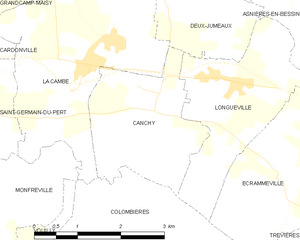
Canchy
- commune in Calvados, France
- Country:
- Postal Code: 14230
- Coordinates: 49° 19' 49" N, 0° 58' 59" E
- GPS tracks (wikiloc): [Link]
- Area: 5.72 sq km
- Population: 203


Géfosse-Fontenay
- commune in Calvados, France
- Country:
- Postal Code: 14230
- Coordinates: 49° 21' 54" N, 1° 5' 37" E
- GPS tracks (wikiloc): [Link]
- Area: 11.11 sq km
- Population: 142

Grandcamp-Maisy
- commune in Calvados, France
- Country:
- Postal Code: 14450
- Coordinates: 49° 23' 15" N, 1° 2' 28" E
- GPS tracks (wikiloc): [Link]
- AboveSeaLevel: 50 м m
- Area: 14.85 sq km
- Population: 1628
- Web site: [Link]


Saint-Germain-du-Pert
- commune in Calvados, France
- Country:
- Postal Code: 14230
- Coordinates: 49° 20' 11" N, 1° 2' 27" E
- GPS tracks (wikiloc): [Link]
- Area: 6.03 sq km
- Population: 180


Cardonville
- commune in Calvados, France
- Country:
- Postal Code: 14230
- Coordinates: 49° 20' 42" N, 1° 3' 53" E
- GPS tracks (wikiloc): [Link]
- Area: 3.29 sq km
- Population: 107

Colombières
- commune in Calvados, France
- Country:
- Postal Code: 14710
- Coordinates: 49° 17' 46" N, 0° 59' 32" E
- GPS tracks (wikiloc): [Link]
- Area: 10.64 sq km
- Population: 211