La Chapelle-Biche (La Chapelle-Biche)

- commune in Orne, France
- Country:

- Postal Code: 61100
- Coordinates: 48° 42' 41" N, 0° 37' 45" E


- GPS tracks (wikiloc): [Link]
- Area: 6.25 sq km
- Population: 527
- Web site: https://lachapellebiche.wordpress.com/
- Wikipedia en: wiki(en)
- Wikipedia: wiki(fr)
- Wikidata storage: Wikidata: Q511013
- Wikipedia Commons Category: [Link]
- Freebase ID: [/m/03qgrr9]
- Freebase ID: [/m/03qgrr9]
- GeoNames ID: Alt: [6457002]
- GeoNames ID: Alt: [6457002]
- SIREN number: [216100958]
- SIREN number: [216100958]
- BnF ID: [152680309]
- BnF ID: [152680309]
- INSEE municipality code: 61095
- INSEE municipality code: 61095
Shares border with regions:


La Chapelle-au-Moine
- commune in Orne, France
- Country:
- Postal Code: 61100
- Coordinates: 48° 42' 29" N, 0° 35' 4" E
- GPS tracks (wikiloc): [Link]
- Area: 5.32 sq km
- Population: 576


Chanu
- commune in Orne, France
- Country:
- Postal Code: 61800
- Coordinates: 48° 43' 43" N, 0° 40' 40" E
- GPS tracks (wikiloc): [Link]
- Area: 15.72 sq km
- Population: 1261
- Web site: [Link]

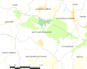
Saint-Clair-de-Halouze
- commune in Orne, France
- Country:
- Postal Code: 61490
- Coordinates: 48° 40' 45" N, 0° 37' 31" E
- GPS tracks (wikiloc): [Link]
- Area: 11.81 sq km
- Population: 869

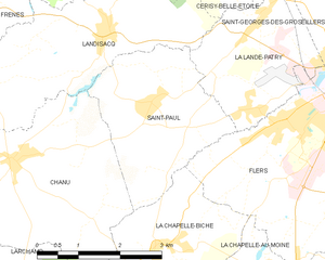
Saint-Paul
- commune in Orne, France
- Country:
- Postal Code: 61100
- Coordinates: 48° 44' 34" N, 0° 37' 57" E
- GPS tracks (wikiloc): [Link]
- Area: 7.96 sq km
- Population: 652

Flers
- commune in Orne, France
- Country:
- Postal Code: 61100
- Coordinates: 48° 44' 54" N, 0° 34' 10" E
- GPS tracks (wikiloc): [Link]
- AboveSeaLevel: 189 м m
- Area: 21.15 sq km
- Population: 14852
- Web site: [Link]