La Chapelle-Monthodon (La Chapelle-Monthodon)
- former commune in Aisne, France
- Country:

- Postal Code: 02330
- Coordinates: 49° 1' 22" N, 3° 38' 8" E


- GPS tracks (wikiloc): [Link]
- Area: 14.28 sq km
- Population: 199
- Wikipedia en: wiki(en)
- Wikipedia: wiki(fr)
- Wikidata storage: Wikidata: Q846425
- Wikipedia Commons Category: [Link]
- Freebase ID: [/m/03m7jds]
- Freebase ID: [/m/03m7jds]
- GeoNames ID: Alt: [6613176]
- GeoNames ID: Alt: [6613176]
- INSEE municipality code: 02161
- INSEE municipality code: 02161
Shares border with regions:

Saint-Agnan
- former commune in Aisne, France
- Country:
- Postal Code: 02330
- Coordinates: 49° 1' 13" N, 3° 35' 41" E
- GPS tracks (wikiloc): [Link]
- Area: 8.07 sq km
- Population: 103

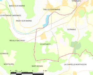
Courthiézy
- commune in Marne, France
- Country:
- Postal Code: 51700
- Coordinates: 49° 3' 9" N, 3° 35' 51" E
- GPS tracks (wikiloc): [Link]
- Area: 5.89 sq km
- Population: 363

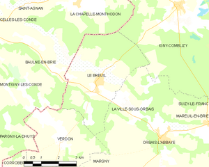
Le Breuil
- commune in Marne, France
- Country:
- Postal Code: 51210
- Coordinates: 48° 58' 32" N, 3° 38' 48" E
- GPS tracks (wikiloc): [Link]
- AboveSeaLevel: 125 м m
- Area: 16.01 sq km
- Population: 393

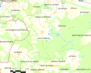
Igny-Comblizy
- commune in Marne, France
- Country:
- Postal Code: 51700
- Coordinates: 49° 1' 7" N, 3° 42' 47" E
- GPS tracks (wikiloc): [Link]
- AboveSeaLevel: 214 м m
- Area: 40.74 sq km
- Population: 393


Dormans
- commune in Marne, France
- Country:
- Postal Code: 51700
- Coordinates: 49° 4' 35" N, 3° 38' 22" E
- GPS tracks (wikiloc): [Link]
- Area: 22.58 sq km
- Population: 2929
- Web site: [Link]

Baulne-en-Brie
- former commune in Aisne, France
- Country:
- Postal Code: 02330
- Coordinates: 48° 59' 14" N, 3° 36' 50" E
- GPS tracks (wikiloc): [Link]
- Area: 18.89 sq km
- Population: 260