La Ferrière (La Ferrière)

- commune in Vendée, France
- Country:

- Postal Code: 85280
- Coordinates: 46° 42' 49" N, 1° 18' 52" E


- GPS tracks (wikiloc): [Link]
- Area: 47.17 sq km
- Population: 5167
- Web site: http://www.laferriere-vendee.fr
- Wikipedia en: wiki(en)
- Wikipedia: wiki(fr)
- Wikidata storage: Wikidata: Q832065
- Wikipedia Commons Category: [Link]
- Freebase ID: [/m/03qltjt]
- GeoNames ID: Alt: [6457155]
- SIREN number: [218500890]
- INSEE municipality code: 85089
Shares border with regions:


Dompierre-sur-Yon
- commune in Vendée, France
- Country:
- Postal Code: 85170
- Coordinates: 46° 44' 15" N, 1° 23' 7" E
- GPS tracks (wikiloc): [Link]
- Area: 33.6 sq km
- Population: 4227
- Web site: [Link]


La Chaize-le-Vicomte
- commune in Vendée, France
- Country:
- Postal Code: 85310
- Coordinates: 46° 40' 20" N, 1° 17' 33" E
- GPS tracks (wikiloc): [Link]
- Area: 49.51 sq km
- Population: 3708
- Web site: [Link]

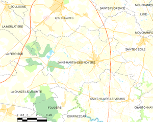
Saint-Martin-des-Noyers
- commune in Vendée, France
- Country:
- Postal Code: 85140
- Coordinates: 46° 43' 18" N, 1° 10' 42" E
- GPS tracks (wikiloc): [Link]
- Area: 41.74 sq km
- Population: 2305
- Web site: [Link]

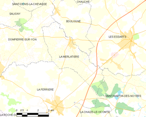
La Merlatière
- commune in Vendée, France
- Country:
- Postal Code: 85140
- Coordinates: 46° 46' 6" N, 1° 18' 3" E
- GPS tracks (wikiloc): [Link]
- Area: 14.86 sq km
- Population: 987
- Web site: [Link]

La Roche-sur-Yon
- commune in Vendée, France
- Country:
- Postal Code: 85000
- Coordinates: 46° 40' 11" N, 1° 25' 40" E
- GPS tracks (wikiloc): [Link]
- AboveSeaLevel: 74 м m
- Area: 87.52 sq km
- Population: 53578
- Web site: [Link]