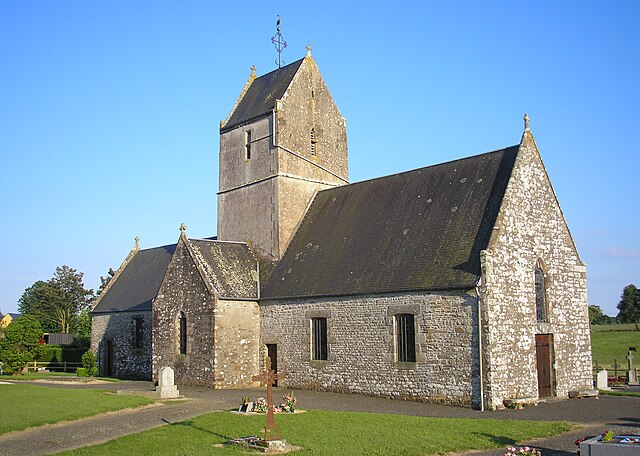
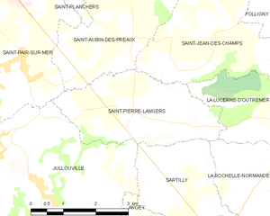
La Lucerne-d'Outremer (La Lucerne-d'Outremer)

- commune in Manche, France
- Country:

- Postal Code: 50320
- Coordinates: 48° 47' 4" N, 1° 25' 36" E


- GPS tracks (wikiloc): [Link]
- Area: 14.48 sq km
- Population: 838
- Wikipedia en: wiki(en)
- Wikipedia: wiki(fr)
- Wikidata storage: Wikidata: Q1063376
- Wikipedia Commons Category: [Link]
- Freebase ID: [/m/03nx975]
- Freebase ID: [/m/03nx975]
- GeoNames ID: Alt: [6456124]
- GeoNames ID: Alt: [6456124]
- SIREN number: [215002817]
- SIREN number: [215002817]
- BnF ID: [152622563]
- BnF ID: [152622563]
- VIAF ID: Alt: [151420335]
- VIAF ID: Alt: [151420335]
- archINFORM location ID: [7678]
- archINFORM location ID: [7678]
- Library of Congress authority ID: Alt: [n93061710]
- Library of Congress authority ID: Alt: [n93061710]
- PACTOLS thesaurus ID: [pcrtQAMKj57GvD]
- PACTOLS thesaurus ID: [pcrtQAMKj57GvD]
- INSEE municipality code: 50281
- INSEE municipality code: 50281
Shares border with regions:


Les Chambres
- former commune in Manche, France
- Country:
- Postal Code: 50320
- Coordinates: 48° 45' 59" N, 1° 23' 17" E
- GPS tracks (wikiloc): [Link]
- Area: 4.18 sq km
- Population: 137


Saint-Jean-des-Champs
- commune in Manche, France
- Country:
- Postal Code: 50320
- Coordinates: 48° 49' 39" N, 1° 27' 53" E
- GPS tracks (wikiloc): [Link]
- Area: 19.4 sq km
- Population: 1388


La Rochelle-Normande
- former commune in Manche, France
- Country:
- Postal Code: 50530
- Coordinates: 48° 45' 54" N, 1° 26' 4" E
- GPS tracks (wikiloc): [Link]
- Area: 7.53 sq km
- Population: 330


La Mouche
- commune in Manche, France
- Country:
- Postal Code: 50320
- Coordinates: 48° 47' 37" N, 1° 20' 59" E
- GPS tracks (wikiloc): [Link]
- Area: 4.43 sq km
- Population: 246
- Web site: [Link]

Folligny
- commune in Manche, France
- Country:
- Postal Code: 50320
- Coordinates: 48° 49' 26" N, 1° 24' 41" E
- GPS tracks (wikiloc): [Link]
- Area: 11.8 sq km
- Population: 1079


Hocquigny
- commune in Manche, France
- Country:
- Postal Code: 50320
- Coordinates: 48° 48' 49" N, 1° 24' 20" E
- GPS tracks (wikiloc): [Link]
- Area: 3.05 sq km
- Population: 185


Champcervon
- former commune in Manche, France
- Country:
- Postal Code: 50320
- Coordinates: 48° 46' 39" N, 1° 23' 43" E
- GPS tracks (wikiloc): [Link]
- Area: 5.63 sq km
- Population: 215


Le Tanu
- commune in Manche, France
- Country:
- Postal Code: 50320
- Coordinates: 48° 48' 59" N, 1° 20' 43" E
- GPS tracks (wikiloc): [Link]
- Area: 10.12 sq km
- Population: 376

Saint-Pierre-Langers
- commune in Manche, France
- Country:
- Postal Code: 50530
- Coordinates: 48° 47' 4" N, 1° 29' 52" E
- GPS tracks (wikiloc): [Link]
- Area: 8.4 sq km
- Population: 565


La Haye-Pesnel
- commune in Manche, France
- Country:
- Postal Code: 50320
- Coordinates: 48° 47' 44" N, 1° 23' 48" E
- GPS tracks (wikiloc): [Link]
- Area: 6.29 sq km
- Population: 1360