
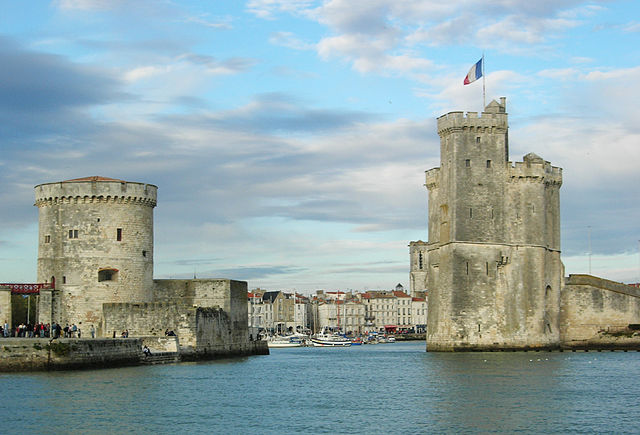
La Rochelle (La Rochelle)

- commune in Charente-Maritime, France
- Country:

- Postal Code: 17000
- Local Dialing Code: 546
- Coordinates: 46° 9' 34" N, 1° 9' 5" E


- GPS tracks (wikiloc): [Link]
- AboveSeaLevel: 4 м m
- Area: 28.43 sq km
- Population: 75404
- Web site: http://www.ville-larochelle.fr
- Wikipedia en: wiki(en)
- Wikipedia: wiki(fr)
- Wikidata storage: Wikidata: Q82185
- Wikipedia Commons Gallery: [Link]
- Wikipedia Commons Category: [Link]
- Wikipedia Commons Maps Category: [Link]
- Freebase ID: [/m/0qb48]
- Freebase ID: [/m/0qb48]
- GeoNames ID: Alt: [3006787]
- GeoNames ID: Alt: [3006787]
- SIREN number: [211703004]
- SIREN number: [211703004]
- BnF ID: [11878109f]
- BnF ID: [11878109f]
- VIAF ID: Alt: [12144647639603028128]
- VIAF ID: Alt: [12144647639603028128]
- OSM relation ID: [117858]
- OSM relation ID: [117858]
- GND ID: Alt: [4111169-2]
- GND ID: Alt: [4111169-2]
- archINFORM location ID: [4994]
- archINFORM location ID: [4994]
- Library of Congress authority ID: Alt: [n81003750]
- Library of Congress authority ID: Alt: [n81003750]
- MusicBrainz area ID: [915a9631-bca8-49f7-a44d-af10e960e357]
- MusicBrainz area ID: [915a9631-bca8-49f7-a44d-af10e960e357]
- Quora topic ID: [La-Rochelle]
- Quora topic ID: [La-Rochelle]
- SUDOC authorities ID: [02655528X]
- SUDOC authorities ID: [02655528X]
- Encyclopædia Britannica Online ID: [place/La-Rochelle]
- Encyclopædia Britannica Online ID: [place/La-Rochelle]
- Gran Enciclopèdia Catalana ID: [0056233]
- Gran Enciclopèdia Catalana ID: [0056233]
- Encyclopædia Universalis ID: [la-rochelle]
- Encyclopædia Universalis ID: [la-rochelle]
- EMLO location ID: [b944658c-14ff-4aa7-8bb4-67d19a37b1f4]
- EMLO location ID: [b944658c-14ff-4aa7-8bb4-67d19a37b1f4]
- Facebook Places ID: [109370652426488]
- Facebook Places ID: [109370652426488]
- Great Russian Encyclopedia Online ID: [2133875]
- Great Russian Encyclopedia Online ID: [2133875]
- ISNI: Alt: [0000 0001 1344 1751]
- ISNI: Alt: [0000 0001 1344 1751]
- BNE ID: Alt: [XX459876]
- BNE ID: Alt: [XX459876]
- BAV ID: [ADV12619050]
- BAV ID: [ADV12619050]
- INSEE municipality code: 17300
- INSEE municipality code: 17300
- US National Archives Identifier: 10045149
- US National Archives Identifier: 10045149
Includes regions:
canton of La Rochelle-7
- canton of France (until March 2015)
- Country:
- Capital: La Rochelle
- Coordinates: 46° 9' 41" N, 1° 8' 56" E
- GPS tracks (wikiloc): [Link]
canton of La Rochelle-4
- canton of France (until March 2015)
- Country:
- Capital: La Rochelle
- Coordinates: 46° 9' 41" N, 1° 8' 56" E
- GPS tracks (wikiloc): [Link]

canton of La Rochelle-1
- canton of France
- Country:
- Capital: La Rochelle
- Coordinates: 46° 9' 41" N, 1° 8' 56" E
- GPS tracks (wikiloc): [Link]
- Population: 26507

canton of La Rochelle-2
- canton of France
- Country:
- Capital: La Rochelle
- Coordinates: 46° 9' 41" N, 1° 8' 56" E
- GPS tracks (wikiloc): [Link]
- Population: 24634
canton of La Rochelle-5
- canton of France
- Country:
- Capital: La Rochelle
- Coordinates: 46° 12' 22" N, 1° 7' 25" E
- GPS tracks (wikiloc): [Link]
canton of La Rochelle-6
- canton of France
- Country:
- Capital: La Rochelle
- Coordinates: 46° 9' 41" N, 1° 8' 56" E
- GPS tracks (wikiloc): [Link]
canton of La Rochelle-8
- canton of France
- Country:
- Capital: La Rochelle
- Coordinates: 46° 10' 5" N, 1° 6' 3" E
- GPS tracks (wikiloc): [Link]
canton of La Rochelle-9
- canton of France
- Country:
- Capital: La Rochelle
- Coordinates: 46° 11' 15" N, 1° 9' 47" E
- GPS tracks (wikiloc): [Link]
Shares border with regions:

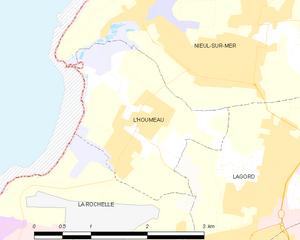
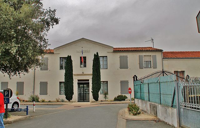
L'Houmeau
- commune in Charente-Maritime, France
- Country:
- Postal Code: 17137
- Coordinates: 46° 11' 35" N, 1° 11' 14" E
- GPS tracks (wikiloc): [Link]
- Area: 4.22 sq km
- Population: 2830
- Web site: [Link]

Lagord
- commune in Charente-Maritime, France
- Country:
- Postal Code: 17140
- Coordinates: 46° 11' 22" N, 1° 9' 15" E
- GPS tracks (wikiloc): [Link]
- Area: 8.04 sq km
- Population: 7153
- Web site: [Link]


Puilboreau
- commune in Charente-Maritime, France
- Country:
- Postal Code: 17138
- Coordinates: 46° 11' 9" N, 1° 7' 2" E
- GPS tracks (wikiloc): [Link]
- Area: 7.88 sq km
- Population: 5933
- Web site: [Link]


Périgny
- commune in Charente-Maritime, France
- Country:
- Postal Code: 17180
- Coordinates: 46° 9' 10" N, 1° 5' 47" E
- GPS tracks (wikiloc): [Link]
- Area: 10.78 sq km
- Population: 8130
- Web site: [Link]


Aytré
- commune in Charente-Maritime, France
- Country:
- Postal Code: 17440
- Coordinates: 46° 8' 3" N, 1° 6' 52" E
- GPS tracks (wikiloc): [Link]
- Area: 12.22 sq km
- Population: 8763
- Web site: [Link]


Rivedoux-Plage
- commune in Charente-Maritime, France
- Country:
- Postal Code: 17940
- Coordinates: 46° 9' 33" N, 1° 16' 32" E
- GPS tracks (wikiloc): [Link]
- Area: 4.52 sq km
- Population: 2291
- Web site: [Link]