Le Gouray (Le Gouray)

- former commune in Côtes-d'Armor, France
- Country:

- Postal Code: 22330
- Coordinates: 48° 19' 38" N, 2° 29' 19" E


- GPS tracks (wikiloc): [Link]
- Area: 30.5 sq km
- Population: 1266
- Web site: http://www.legouray.fr
- Wikipedia en: wiki(en)
- Wikipedia: wiki(fr)
- Wikidata storage: Wikidata: Q863929
- Wikipedia Commons Category: [Link]
- Freebase ID: [/m/03hkn9v]
- GeoNames ID: Alt: [6456763]
- BnF ID: [15251067r]
- INSEE municipality code: 22066
Shares border with regions:

Plénée-Jugon
- commune in Côtes-d'Armor, France
- Country:
- Postal Code: 22640
- Coordinates: 48° 21' 51" N, 2° 24' 2" E
- GPS tracks (wikiloc): [Link]
- Area: 61.36 sq km
- Population: 2406

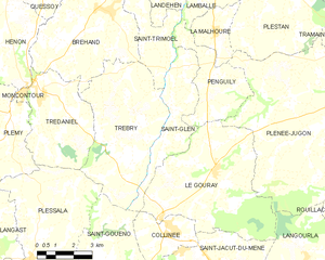
Saint-Glen
- commune in Côtes-d'Armor, France
- Country:
- Postal Code: 22510
- Coordinates: 48° 21' 34" N, 2° 31' 24" E
- GPS tracks (wikiloc): [Link]
- Area: 11.51 sq km
- Population: 610
- Web site: [Link]


Langourla
- former commune in Côtes-d'Armor, France
- Country:
- Postal Code: 22330
- Coordinates: 48° 17' 6" N, 2° 24' 57" E
- GPS tracks (wikiloc): [Link]
- Area: 21.41 sq km
- Population: 493


Saint-Jacut-du-Mené
- former commune in Côtes-d'Armor, France
- Country:
- Postal Code: 22330
- Coordinates: 48° 17' 1" N, 2° 28' 54" E
- GPS tracks (wikiloc): [Link]
- Area: 19.81 sq km
- Population: 741
- Web site: [Link]


Penguily
- commune in Côtes-d'Armor, France
- Country:
- Postal Code: 22510
- Coordinates: 48° 22' 20" N, 2° 29' 42" E
- GPS tracks (wikiloc): [Link]
- Area: 10.49 sq km
- Population: 611