Le Puy-en-Velay (Le Puy-en-Velay)


- commune in Haute-Loire, France
- Country:

- Postal Code: 43000
- Coordinates: 45° 2' 36" N, 3° 53' 6" E


- GPS tracks (wikiloc): [Link]
- AboveSeaLevel: 630 м m
- Area: 16.79 sq km
- Population: 18909
- Web site: http://www.mairie-le-puy-en-velay.fr
- Wikipedia en: wiki(en)
- Wikipedia: wiki(fr)
- Wikidata storage: Wikidata: Q184359
- Wikipedia Commons Gallery: [Link]
- Wikipedia Commons Category: [Link]
- Wikipedia Commons Maps Category: [Link]
- Freebase ID: [/m/03wmqj]
- Freebase ID: [/m/03wmqj]
- Freebase ID: [/m/03wmqj]
- Freebase ID: [/m/03wmqj]
- Freebase ID: [/m/03wmqj]
- Freebase ID: [/m/03wmqj]
- GeoNames ID: Alt: [3002465]
- GeoNames ID: Alt: [3002465]
- GeoNames ID: Alt: [3002465]
- GeoNames ID: Alt: [3002465]
- GeoNames ID: Alt: [3002465]
- GeoNames ID: Alt: [3002465]
- SIREN number: [214301574]
- SIREN number: [214301574]
- SIREN number: [214301574]
- SIREN number: [214301574]
- SIREN number: [214301574]
- SIREN number: [214301574]
- BnF ID: [15260061n]
- BnF ID: [15260061n]
- BnF ID: [15260061n]
- BnF ID: [15260061n]
- BnF ID: [15260061n]
- BnF ID: [15260061n]
- VIAF ID: Alt: [147339129]
- VIAF ID: Alt: [147339129]
- VIAF ID: Alt: [147339129]
- VIAF ID: Alt: [147339129]
- VIAF ID: Alt: [147339129]
- VIAF ID: Alt: [147339129]
- GND ID: Alt: [4111265-9]
- GND ID: Alt: [4111265-9]
- GND ID: Alt: [4111265-9]
- GND ID: Alt: [4111265-9]
- GND ID: Alt: [4111265-9]
- GND ID: Alt: [4111265-9]
- archINFORM location ID: [6799]
- archINFORM location ID: [6799]
- archINFORM location ID: [6799]
- archINFORM location ID: [6799]
- archINFORM location ID: [6799]
- archINFORM location ID: [6799]
- Library of Congress authority ID: Alt: [n82052561]
- Library of Congress authority ID: Alt: [n82052561]
- Library of Congress authority ID: Alt: [n82052561]
- Library of Congress authority ID: Alt: [n82052561]
- Library of Congress authority ID: Alt: [n82052561]
- Library of Congress authority ID: Alt: [n82052561]
- MusicBrainz area ID: [33610dcd-094d-4900-9135-8d14062bcb83]
- MusicBrainz area ID: [33610dcd-094d-4900-9135-8d14062bcb83]
- MusicBrainz area ID: [33610dcd-094d-4900-9135-8d14062bcb83]
- MusicBrainz area ID: [33610dcd-094d-4900-9135-8d14062bcb83]
- MusicBrainz area ID: [33610dcd-094d-4900-9135-8d14062bcb83]
- MusicBrainz area ID: [33610dcd-094d-4900-9135-8d14062bcb83]
- WOEID: [604339]
- WOEID: [604339]
- WOEID: [604339]
- WOEID: [604339]
- WOEID: [604339]
- WOEID: [604339]
- SUDOC authorities ID: [026554305]
- SUDOC authorities ID: [026554305]
- SUDOC authorities ID: [026554305]
- SUDOC authorities ID: [026554305]
- SUDOC authorities ID: [026554305]
- SUDOC authorities ID: [026554305]
- Encyclopædia Britannica Online ID: [place/Le-Puy-en-Velay]
- Encyclopædia Britannica Online ID: [place/Le-Puy-en-Velay]
- Encyclopædia Britannica Online ID: [place/Le-Puy-en-Velay]
- Encyclopædia Britannica Online ID: [place/Le-Puy-en-Velay]
- Encyclopædia Britannica Online ID: [place/Le-Puy-en-Velay]
- Encyclopædia Britannica Online ID: [place/Le-Puy-en-Velay]
- Encyclopædia Universalis ID: [le-puy-en-velay]
- Encyclopædia Universalis ID: [le-puy-en-velay]
- Encyclopædia Universalis ID: [le-puy-en-velay]
- Encyclopædia Universalis ID: [le-puy-en-velay]
- Encyclopædia Universalis ID: [le-puy-en-velay]
- Encyclopædia Universalis ID: [le-puy-en-velay]
- Great Russian Encyclopedia Online ID: [2141193]
- Great Russian Encyclopedia Online ID: [2141193]
- Great Russian Encyclopedia Online ID: [2141193]
- Great Russian Encyclopedia Online ID: [2141193]
- Great Russian Encyclopedia Online ID: [2141193]
- Great Russian Encyclopedia Online ID: [2141193]
- Digital Atlas of the Roman Empire ID: [162]
- Digital Atlas of the Roman Empire ID: [162]
- Digital Atlas of the Roman Empire ID: [162]
- Digital Atlas of the Roman Empire ID: [162]
- Digital Atlas of the Roman Empire ID: [162]
- Digital Atlas of the Roman Empire ID: [162]
- Pleiades ID: [167646]
- Pleiades ID: [167646]
- Pleiades ID: [167646]
- Pleiades ID: [167646]
- Pleiades ID: [167646]
- Pleiades ID: [167646]
- INSEE municipality code: 43157
- INSEE municipality code: 43157
- INSEE municipality code: 43157
- INSEE municipality code: 43157
- INSEE municipality code: 43157
- INSEE municipality code: 43157
Shares border with regions:


Aiguilhe
- commune in Haute-Loire, France
- Country:
- Postal Code: 43000
- Coordinates: 45° 3' 3" N, 3° 53' 5" E
- GPS tracks (wikiloc): [Link]
- AboveSeaLevel: 650 м m
- Area: 1.1 sq km
- Population: 1551

Vals-près-le-Puy
- commune in Haute-Loire, France
- Country:
- Postal Code: 43750
- Coordinates: 45° 1' 42" N, 3° 52' 29" E
- GPS tracks (wikiloc): [Link]
- Area: 5.12 sq km
- Population: 3328
- Web site: [Link]

Saint-Christophe-sur-Dolaison
- commune in Haute-Loire, France
- Country:
- Postal Code: 43370
- Coordinates: 44° 59' 49" N, 3° 49' 13" E
- GPS tracks (wikiloc): [Link]
- Area: 27.34 sq km
- Population: 952
- Web site: [Link]


Cussac-sur-Loire
- commune in Haute-Loire, France
- Country:
- Postal Code: 43370
- Coordinates: 44° 59' 24" N, 3° 52' 16" E
- GPS tracks (wikiloc): [Link]
- AboveSeaLevel: 660 м m
- Area: 10.27 sq km
- Population: 1751
- Web site: [Link]


Coubon
- commune in Haute-Loire, France
- Country:
- Postal Code: 43700
- Coordinates: 44° 59' 49" N, 3° 55' 4" E
- GPS tracks (wikiloc): [Link]
- Area: 22.73 sq km
- Population: 3145


Brives-Charensac
- commune in Haute-Loire, France
- Country:
- Postal Code: 43700
- Coordinates: 45° 2' 48" N, 3° 55' 36" E
- GPS tracks (wikiloc): [Link]
- Area: 4.87 sq km
- Population: 4103


Polignac
- commune in Haute-Loire, France
- Country:
- Postal Code: 43000
- Coordinates: 45° 4' 11" N, 3° 51' 34" E
- GPS tracks (wikiloc): [Link]
- Area: 33.05 sq km
- Population: 2830


Chadrac
- commune in Haute-Loire, France
- Country:
- Postal Code: 43770
- Coordinates: 45° 3' 49" N, 3° 54' 21" E
- GPS tracks (wikiloc): [Link]
- Area: 2.48 sq km
- Population: 2583

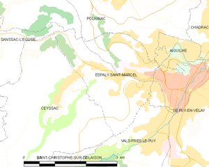
Espaly-Saint-Marcel
- commune in Haute-Loire, France
- Country:
- Postal Code: 43000
- Coordinates: 45° 2' 46" N, 3° 51' 34" E
- GPS tracks (wikiloc): [Link]
- Area: 6.29 sq km
- Population: 3530
- Web site: [Link]