Les Alleuds (Les Alleuds)

- former commune in Deux-Sèvres, France
- Country:

- Postal Code: 79190
- Coordinates: 46° 9' 50" N, 0° 0' 26" E


- GPS tracks (wikiloc): [Link]
- Area: 9.15 sq km
- Population: 274
- Wikipedia en: wiki(en)
- Wikipedia: wiki(fr)
- Wikidata storage: Wikidata: Q1070301
- Wikipedia Commons Category: [Link]
- Freebase ID: [/m/03mg1d9]
- GeoNames ID: Alt: [6457200]
- BnF ID: [152761429]
- VIAF ID: Alt: [246315275]
- PACTOLS thesaurus ID: [pcrtNSR1A43Vuv]
- INSEE municipality code: 79006
Shares border with regions:


Gournay-Loizé
- former commune in Deux-Sèvres, France
- Country:
- Postal Code: 79110
- Coordinates: 46° 9' 0" N, 0° 3' 0" E
- GPS tracks (wikiloc): [Link]
- AboveSeaLevel: 169 м m
- Area: 23.23 sq km
- Population: 605


Clussais-la-Pommeraie
- commune in Deux-Sèvres, France
- Country:
- Postal Code: 79190
- Coordinates: 46° 11' 9" N, 0° 1' 56" E
- GPS tracks (wikiloc): [Link]
- Area: 31.03 sq km
- Population: 591
- Web site: [Link]
Saint-Vincent-la-Châtre
- commune in Deux-Sèvres, France
- Country:
- Postal Code: 79500
- Coordinates: 46° 13' 18" N, 0° 2' 10" E
- GPS tracks (wikiloc): [Link]
- Area: 21.18 sq km
- Population: 674

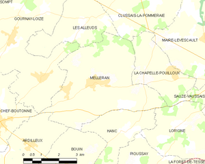
Melleran
- commune in Deux-Sèvres, France
- Country:
- Postal Code: 79190
- Coordinates: 46° 7' 52" N, 0° 0' 5" E
- GPS tracks (wikiloc): [Link]
- Area: 19.9 sq km
- Population: 519
- Web site: [Link]