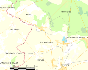
Les Menus (Les Menus)

- commune in Orne, France
- Country:

- Postal Code: 61290
- Coordinates: 48° 31' 27" N, 0° 56' 3" E


- GPS tracks (wikiloc): [Link]
- Area: 11.81 sq km
- Population: 221
- Wikipedia en: wiki(en)
- Wikipedia: wiki(fr)
- Wikidata storage: Wikidata: Q1155684
- Wikipedia Commons Category: [Link]
- Freebase ID: [/m/03qgqgj]
- Freebase ID: [/m/03qgqgj]
- GeoNames ID: Alt: [6456306]
- GeoNames ID: Alt: [6456306]
- SIREN number: [216102749]
- SIREN number: [216102749]
- BnF ID: [152682060]
- BnF ID: [152682060]
- INSEE municipality code: 61274
- INSEE municipality code: 61274
Shares border with regions:

Fontaine-Simon
- commune in Eure-et-Loir, France
- Country:
- Postal Code: 28240
- Coordinates: 48° 30' 13" N, 1° 1' 9" E
- GPS tracks (wikiloc): [Link]
- Area: 16.88 sq km
- Population: 949


Le Pas-Saint-l'Homer
- commune in Orne, France
- Country:
- Postal Code: 61290
- Coordinates: 48° 29' 46" N, 0° 55' 59" E
- GPS tracks (wikiloc): [Link]
- Area: 9.43 sq km
- Population: 145


Neuilly-sur-Eure
- former commune in Orne, France
- Country:
- Postal Code: 61290
- Coordinates: 48° 32' 31" N, 0° 54' 12" E
- GPS tracks (wikiloc): [Link]
- Area: 21.47 sq km
- Population: 601

Moutiers-au-Perche
- commune in Orne, France
- Country:
- Postal Code: 61110
- Coordinates: 48° 28' 38" N, 0° 50' 49" E
- GPS tracks (wikiloc): [Link]
- Area: 33.61 sq km
- Population: 421


Manou
- commune in Eure-et-Loir, France
- Country:
- Postal Code: 28240
- Coordinates: 48° 31' 8" N, 0° 58' 57" E
- GPS tracks (wikiloc): [Link]
- Area: 13.38 sq km
- Population: 590