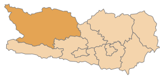
Lienz District (Bezirk Lienz)

- district of Austria
 Hiking in Lienz District
Lienz District, located in the eastern part of Tyrol, Austria, is a stunning area for hiking, known for its breathtaking alpine landscapes, picturesque villages, and a variety of trails suitable for all levels of hikers. Here are some key highlights and recommendations for hiking in this beautiful region:
Trails and Routes
-
Dolomites of Lienz: The region features a segment of the South Tyrolean Dolomites, offering spectacular views and a range of trails. The hike to the Glocknerblick or various routes around the Hochstein and Lienzer Dolomiten are particularly popular.
-
Lienz to Dolomites: The trails leading from Lienz into the Dolomites provide a great mix of easy walks and more challenging treks. The Lienzer Höhenweg is a scenic high-altitude trail that showcases the area’s stunning natural beauty.
-
Zettersfeld and Hochstein: These two local mountains have accessible hiking trails, including circular routes with panoramic views of Lienz and the surrounding peaks.
-
Pine & Pasture Trails: Trails around the area often pass through serene forests and alpine meadows, perfect for those looking for a peaceful hike. The Lienzer Moos nature reserve offers marked paths through beautiful wetland areas.
Difficulty Levels
- Easy: Many gentle trails are suitable for families and casual walkers, especially around the valley floor and through nature reserves.
- Moderate: There are plenty of hill hikes that may involve some elevation gain but are manageable for those with a moderate fitness level.
- Difficult: More experienced hikers will find challenging routes, particularly in the higher elevations of the Dolomites.
Best Season
- Summer: The prime hiking season is from June to September when the weather is typically warm and the trails are clear of snow.
- Autumn: Fall is also a beautiful time to hike, with stunning foliage and fewer crowds.
Tips and Considerations
- Weather: Be prepared for changing weather conditions in the mountains. It’s wise to check the forecast and carry appropriate gear.
- Navigation: While many trails are well-marked, it's useful to carry a map or GPS device, particularly for more remote routes.
- Safety: Always inform someone of your hiking plans and consider hiking with a partner, especially on more isolated trails.
Local Culture
The region is rich in Tyrolean culture, so take time to explore villages like Lienz, where you can enjoy local cuisine and hospitality after a day of hiking.
In summary, Lienz District is a fantastic destination for hikers of all abilities, offering a diverse range of trails, stunning scenery, and cultural experiences. Whether you're looking for a leisurely walk or a challenging hike, this area has something to offer everyone.
- Country:

- Capital: Lienz
- Licence Plate Code: LZ
- Coordinates: 46° 49' 0" N, 12° 46' 0" E


- GPS tracks (wikiloc): [Link]
- AboveSeaLevel: 1961 м m
- Area: 2019.87 sq km
- Population: 49033
- Web site: http://www.tirol.gv.at/bh-lienz
- Wikipedia en: wiki(en)
- Wikipedia: wiki(de)
- Wikidata storage: Wikidata: Q251931
- Wikipedia Commons Category: [Link]
- Wikipedia Commons Maps Category: [Link]
- Freebase ID: [/m/06sjg2]
- GeoNames ID: Alt: [2772504]
- VIAF ID: Alt: [248994486]
- GND ID: Alt: [4099633-5]
- archINFORM location ID: [14620]
Includes regions:
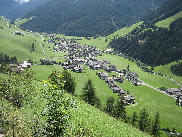

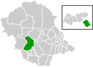
Innervillgraten
- municipality in Austria
Hiking in Innervillgraten
Innervillgraten, located in the picturesque East Tyrol region of Austria, is a hidden gem for hiking enthusiasts. Surrounded by stunning mountain scenery, this charming village offers a wealth of hiking trails suitable for various skill levels, making it a perfect destination for both families and serious trekkers....
- Country:
- Postal Code: 9932
- Local Dialing Code: 04843
- Licence Plate Code: LZ
- Coordinates: 46° 48' 24" N, 12° 22' 23" E
- GPS tracks (wikiloc): [Link]
- AboveSeaLevel: 1402 м m
- Area: 87.8 sq km
- Population: 938
- Web site: [Link]
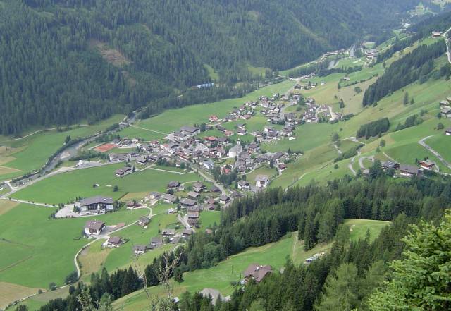
Untertilliach
- municipality in Austria
Hiking in Untertilliach
Untertilliach is a picturesque village located in the Lesachtal Valley of Austria, known for its stunning alpine scenery and extensive hiking opportunities. Nestled in the heart of the eastern Alps, the area is a paradise for nature lovers and hikers....
- Country:
- Postal Code: 9943
- Local Dialing Code: 04847
- Licence Plate Code: LZ
- Coordinates: 46° 42' 13" N, 12° 40' 39" E
- GPS tracks (wikiloc): [Link]
- AboveSeaLevel: 1235 м m
- Area: 36.3 sq km
- Population: 237

Matrei in Osttirol
- municipality in Austria
Hiking in Matrei in Osttirol
Matrei in Osttirol is a picturesque village located in the East Tyrol region of Austria, surrounded by stunning mountain scenery, making it an excellent destination for hiking enthusiasts. Here’s what you can expect from hiking in this beautiful area:...
- Country:
- Postal Code: 9971
- Local Dialing Code: 04875
- Licence Plate Code: LZ
- Coordinates: 47° 3' 30" N, 12° 30' 25" E
- GPS tracks (wikiloc): [Link]
- AboveSeaLevel: 1949 м m
- Area: 277.8 sq km
- Population: 4667
- Web site: [Link]
Sankt Jakob in Defereggen
- municipality in Austria
Hiking in Sankt Jakob in Defereggen
St. Jakob in Defereggen, located in the Austrian Alps in the East Tyrol region, is a fantastic destination for hiking enthusiasts. The area is known for its stunning natural landscapes, diverse flora and fauna, and breathtaking mountain views. Here are some key highlights about hiking in this beautiful area:...
- Country:
- Postal Code: 9963
- Local Dialing Code: 04873
- Licence Plate Code: LZ
- Coordinates: 46° 56' 30" N, 12° 14' 48" E
- GPS tracks (wikiloc): [Link]
- AboveSeaLevel: 2570 м m
- Area: 186 sq km
- Population: 848
- Web site: [Link]


Abfaltersbach
- municipality in Austria
Hiking in Abfaltersbach
Abfaltersbach is a picturesque village located in the East Tyrol region of Austria, surrounded by stunning mountain landscapes, making it an excellent spot for hiking enthusiasts. Here are some key points to consider when hiking in Abfaltersbach:...
- Country:
- Postal Code: 9913
- Local Dialing Code: 04846
- Licence Plate Code: LZ
- Coordinates: 46° 45' 37" N, 12° 32' 31" E
- GPS tracks (wikiloc): [Link]
- AboveSeaLevel: 983 м m
- Area: 10.27 sq km
- Population: 630
- Web site: [Link]


Lienz
- municipality in Tyrol, Austria
Hiking in Lienz
Lienz, located in the Austrian province of Tyrol, is a fantastic destination for hiking enthusiasts. The region is known for its stunning alpine scenery, charming villages, and a variety of hiking trails that cater to different skill levels. Here are some key highlights of hiking in Lienz:...
- Country:
- Postal Code: A–9900
- Local Dialing Code: 4852
- Licence Plate Code: LZ
- Coordinates: 46° 49' 47" N, 12° 46' 11" E
- GPS tracks (wikiloc): [Link]
- AboveSeaLevel: 673 м m
- Area: 15.94 sq km
- Population: 11844
- Web site: [Link]

Ainet
- municipality in Austria
Hiking in Ainet
Ainet, a charming village located in the Tyrol region of Austria, offers beautiful hiking opportunities surrounded by stunning alpine scenery. The area is known for its picturesque landscapes, making it an ideal destination for hikers of all levels. Here are some key points to consider when hiking in Ainet:...
- Country:
- Postal Code: 9951
- Local Dialing Code: 04853
- Licence Plate Code: LZ
- Coordinates: 46° 51' 0" N, 12° 41' 0" E
- GPS tracks (wikiloc): [Link]
- AboveSeaLevel: 747 м m
- Area: 40.43 sq km
- Population: 936
- Web site: [Link]


Amlach
- municipality in Austria
Hiking in Amlach
Amlach is a small village located in Austria, near the picturesque town of Lienz in the state of Tyrol. It’s situated in a region known for its stunning natural landscapes, making it a great spot for hiking enthusiasts. Here are key aspects to consider when planning a hike in Amlach:...
- Country:
- Postal Code: 9908
- Local Dialing Code: 04852
- Licence Plate Code: LZ
- Coordinates: 46° 48' 48" N, 12° 45' 40" E
- GPS tracks (wikiloc): [Link]
- AboveSeaLevel: 689 м m
- Area: 22.49 sq km
- Population: 489
- Web site: [Link]
Iselsberg-Stronach
- municipality in Austria
Hiking in Iselsberg-Stronach
Iselsberg-Stronach is located in the stunning region of East Tyrol in Austria, and it's known for its picturesque landscapes, beautiful mountain scenery, and a variety of hiking opportunities. Whether you're a beginner or an experienced hiker, this area has trails that can accommodate all levels....
- Country:
- Postal Code: 9992
- Local Dialing Code: 04852
- Licence Plate Code: LZ
- Coordinates: 46° 50' 1" N, 12° 50' 52" E
- GPS tracks (wikiloc): [Link]
- AboveSeaLevel: 1117 м m
- Area: 17.96 sq km
- Population: 596
- Web site: [Link]


Anras
- municipality in Austria
Hiking in Anras
Anras is a picturesque village located in the eastern Tyrol region of Austria, known for its beautiful landscapes and outdoor recreational opportunities. Hiking in this area offers a chance to explore the stunning natural surroundings, including lush forests, alpine meadows, and mountain trails....
- Country:
- Postal Code: 9912
- Local Dialing Code: 04846
- Licence Plate Code: LZ
- Coordinates: 46° 46' 26" N, 12° 33' 39" E
- GPS tracks (wikiloc): [Link]
- AboveSeaLevel: 1261 м m
- Area: 58.41 sq km
- Population: 1233
- Web site: [Link]


Dölsach
- municipality in Austria
Hiking in Dölsach
Dölsach is a beautiful village located in the East Tyrol region of Austria, near Lienz, surrounded by stunning alpine scenery that offers a variety of hiking opportunities for all skill levels. Here are some highlights of hiking in Dölsach:...
- Country:
- Postal Code: 9991
- Local Dialing Code: 04852
- Licence Plate Code: LZ
- Coordinates: 46° 49' 40" N, 12° 50' 25" E
- GPS tracks (wikiloc): [Link]
- AboveSeaLevel: 731 м m
- Area: 24.16 sq km
- Population: 2338
- Web site: [Link]

Schlaiten
- municipality in Austria
Hiking in Schlaiten
Schlaiten is a beautiful area located in Austria, known for its picturesque landscapes, lush forests, and a variety of hiking trails that cater to different skill levels. Here are some key points about hiking in Schlaiten:...
- Country:
- Postal Code: 9954
- Local Dialing Code: 04853
- Licence Plate Code: LZ
- Coordinates: 46° 52' 38" N, 12° 39' 21" E
- GPS tracks (wikiloc): [Link]
- AboveSeaLevel: 876 м m
- Area: 36.64 sq km
- Population: 474
- Web site: [Link]


Nußdorf-Debant
- municipality in Austria
Hiking in Nußdorf-Debant
Nußdorf-Debant is a charming village in Austria, situated in the beautiful East Tyrol region near the Austrian Alps. This area is known for its stunning landscapes, rich natural beauty, and a variety of hiking opportunities suitable for all skill levels....
- Country:
- Postal Code: 9990
- Local Dialing Code: 4852
- Licence Plate Code: LZ
- Coordinates: 46° 49' 54" N, 12° 48' 53" E
- GPS tracks (wikiloc): [Link]
- AboveSeaLevel: 674 м m
- Area: 53.44 sq km
- Population: 3325
- Web site: [Link]

Außervillgraten
- municipality in Austria
Hiking in Außervillgraten
Außervillgraten is a picturesque village located in the Tyrolean Valleys of Austria, known for its stunning alpine scenery, traditional architecture, and a variety of hiking opportunities. Here are some highlights and considerations for hiking in the area:...
- Country:
- Postal Code: 9931
- Local Dialing Code: 04843
- Licence Plate Code: LZ
- Coordinates: 46° 47' 12" N, 12° 25' 43" E
- GPS tracks (wikiloc): [Link]
- AboveSeaLevel: 1287 м m
- Area: 79.1 sq km
- Population: 760
- Web site: [Link]


Virgen
- municipality in Austria
Hiking in Virgen
Virgen, a picturesque village nestled in the Alps of Austria, is an excellent destination for hiking enthusiasts. Located in the East Tyrol region, Virgen is known for its stunning natural landscapes, charming village atmosphere, and a plethora of hiking trails that cater to all levels of experience. Here are some key highlights about hiking in this area:...
- Country:
- Postal Code: 9972
- Local Dialing Code: 04874
- Licence Plate Code: LZ
- Coordinates: 47° 0' 13" N, 12° 27' 29" E
- GPS tracks (wikiloc): [Link]
- AboveSeaLevel: 1194 м m
- Area: 88.8 sq km
- Population: 2199
- Web site: [Link]


Prägraten am Großvenediger
- municipality in Austria
Hiking in Prägraten am Großvenediger
Prägraten am Großvenediger is a beautiful village located in the Hohe Tauern National Park in Austria, renowned for its stunning alpine scenery and diverse hiking opportunities. Here's an overview of what you can expect when hiking in this area:...
- Country:
- Postal Code: 9974
- Local Dialing Code: 04877
- Licence Plate Code: LZ
- Coordinates: 47° 1' 0" N, 12° 22' 0" E
- GPS tracks (wikiloc): [Link]
- AboveSeaLevel: 1312 м m
- Area: 180.36 sq km
- Population: 1149
- Web site: [Link]


Sillian
- municipality in Austria
Hiking in Sillian
Sillian, located in the eastern part of Tyrol, Austria, is a fantastic destination for hiking enthusiasts. Nestled amidst stunning alpine landscapes, Sillian offers a wide range of trails that cater to all skill levels, from gentle walks to challenging mountain hikes....
- Country:
- Postal Code: 9920
- Local Dialing Code: 04842
- Licence Plate Code: LZ
- Coordinates: 46° 45' 10" N, 12° 25' 16" E
- GPS tracks (wikiloc): [Link]
- AboveSeaLevel: 1103 м m
- Area: 36.26 sq km
- Population: 2051
- Web site: [Link]


Strassen
- municipality in Austria
Hiking in Strassen
Strassen, located in the Tyrol region of Austria, offers a picturesque backdrop for hiking enthusiasts. Nestled in the Ötztal Alps, it’s surrounded by stunning mountain landscapes, lush valleys, and crystal-clear streams. Here are some highlights and tips for hiking in and around Strassen:...
- Country:
- Postal Code: 9918
- Local Dialing Code: 04846
- Licence Plate Code: LZ
- Coordinates: 46° 44' 58" N, 12° 29' 17" E
- GPS tracks (wikiloc): [Link]
- AboveSeaLevel: 1099 м m
- Area: 17.05 sq km
- Population: 808
- Web site: [Link]

Sankt Johann im Walde
- municipality in Austria
Hiking in Sankt Johann im Walde
Sankt Johann im Walde is a charming village located in the region of Tyrol, Austria, known for its stunning natural landscapes, rich cultural heritage, and excellent hiking opportunities. The area is surrounded by beautiful mountains, lush forests, and serene meadows, making it a perfect destination for nature enthusiasts and hiking lovers....
- Country:
- Postal Code: 9952
- Local Dialing Code: 04872
- Licence Plate Code: LZ
- Coordinates: 46° 54' 38" N, 12° 37' 25" E
- GPS tracks (wikiloc): [Link]
- AboveSeaLevel: 853 м m
- Area: 32.82 sq km
- Population: 285


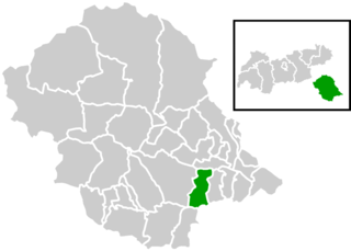
Nikolsdorf
- municipality in Austria
Hiking in Nikolsdorf
Nikolsdorf is a charming village located in Austria, nestled in the beautiful region of East Tyrol. The area is surrounded by stunning mountain landscapes, making it an excellent choice for hiking enthusiasts. Here are some key points to consider when hiking in and around Nikolsdorf:...
- Country:
- Postal Code: 9782
- Local Dialing Code: 04858
- Licence Plate Code: LZ
- Coordinates: 46° 47' 6" N, 12° 54' 21" E
- GPS tracks (wikiloc): [Link]
- AboveSeaLevel: 675 м m
- Area: 33.61 sq km
- Population: 894
- Web site: [Link]


Oberlienz
- municipality in Austria
Hiking in Oberlienz
Oberlienz, located in the East Tyrol region of Austria, is a beautiful destination for hiking enthusiasts. Nestled in the Alps and surrounded by stunning mountain landscapes, it offers a variety of trails suitable for hikers of all levels, from beginners to experienced trekkers....
- Country:
- Postal Code: 9903
- Local Dialing Code: 04852
- Licence Plate Code: LZ
- Coordinates: 46° 50' 38" N, 12° 43' 48" E
- GPS tracks (wikiloc): [Link]
- AboveSeaLevel: 756 м m
- Area: 33.8 sq km
- Population: 1485
- Web site: [Link]

Sankt Veit in Defereggen
- municipality in Austria
Hiking in Sankt Veit in Defereggen
Sankt Veit in Defereggen, located in the beautiful East Tyrol region of Austria, is a fantastic destination for hiking enthusiasts. The area is known for its stunning alpine scenery, pristine nature, and a variety of well-marked hiking trails suitable for all levels of expertise....
- Country:
- Postal Code: 9962
- Local Dialing Code: 04879
- Licence Plate Code: LZ
- Coordinates: 46° 54' 43" N, 12° 24' 22" E
- GPS tracks (wikiloc): [Link]
- AboveSeaLevel: 1506 м m
- Area: 61.48 sq km
- Population: 670
- Web site: [Link]


Heinfels
- municipality in Austria
Hiking in Heinfels
Heinfels is a charming village located in the East Tyrol region of Austria, surrounded by the stunning scenery of the Austrian Alps. The area offers a variety of hiking opportunities for all skill levels, with trails that showcase the beautiful landscapes, valleys, and mountain vistas....
- Country:
- Postal Code: 9919
- Local Dialing Code: 04842
- Licence Plate Code: LZ
- Coordinates: 46° 45' 40" N, 12° 26' 23" E
- GPS tracks (wikiloc): [Link]
- AboveSeaLevel: 1078 м m
- Area: 14.56 sq km
- Population: 977
- Web site: [Link]

Leisach
- municipality in Austria
Hiking in Leisach
Leisach, located in the picturesque province of East Tyrol in Austria, offers some truly stunning hiking opportunities. Set against the backdrop of the majestic Alps, the area is known for its breathtaking landscapes, charming villages, and rich natural biodiversity. Here are some highlights for hiking in and around Leisach:...
- Country:
- Postal Code: 9909
- Local Dialing Code: 04852
- Licence Plate Code: LZ
- Coordinates: 46° 48' 34" N, 12° 45' 0" E
- GPS tracks (wikiloc): [Link]
- AboveSeaLevel: 710 м m
- Area: 33.3 sq km
- Population: 729
- Web site: [Link]


Gaimberg
- municipality in Austria
Hiking in Gaimberg
Gaimberg, located in Austria near the town of Lienz in the East Tyrol region, offers a variety of hiking opportunities for outdoor enthusiasts. The picturesque alpine scenery, lush meadows, and stunning views of the surrounding mountains make it a fantastic destination for both novice and experienced hikers....
- Country:
- Postal Code: 9905
- Local Dialing Code: 04852
- Licence Plate Code: LZ
- Coordinates: 46° 50' 43" N, 12° 47' 8" E
- GPS tracks (wikiloc): [Link]
- AboveSeaLevel: 758 м m
- Area: 7.28 sq km
- Population: 822
- Web site: [Link]
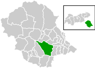
Hopfgarten in Defereggen
- municipality in Austria
Hiking in Hopfgarten in Defereggen
Hopfgarten in Defereggen is a picturesque village located in the East Tyrol region of Austria, surrounded by stunning landscapes and the beautiful Hohe Tauern National Park. It's an excellent location for hiking enthusiasts, offering a variety of trails that cater to different skill levels....
- Country:
- Postal Code: 9961
- Local Dialing Code: 04872
- Licence Plate Code: LZ
- Coordinates: 46° 55' 16" N, 12° 31' 9" E
- GPS tracks (wikiloc): [Link]
- AboveSeaLevel: 1107 м m
- Area: 73.17 sq km
- Population: 704
- Web site: [Link]


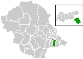
Lavant
- municipality in the district of Lienz, East Tyrol, Austria
Hiking in Lavant
Lavant is a charming town in the Tyrol region of Austria, known for its stunning alpine scenery and diverse hiking opportunities. Here are some key points to consider if you're planning a hiking trip in Lavant:...
- Country:
- Postal Code: 9906
- Local Dialing Code: 04852
- Licence Plate Code: LZ
- Coordinates: 46° 47' 56" N, 12° 50' 17" E
- GPS tracks (wikiloc): [Link]
- AboveSeaLevel: 675 м m
- Area: 22.55 sq km
- Population: 320
- Web site: [Link]


Obertilliach
- place and municipality in Tyrol, Austria
Hiking in Obertilliach
Obertilliach is a picturesque village located in the East Tyrol region of Austria, surrounded by the stunning landscapes of the Lienz Dolomites and the Carnic Alps. It's an excellent destination for hikers of all levels, offering a mix of well-marked trails, breathtaking views, and a serene environment. Here are some highlights you can expect while hiking in and around Obertilliach:...
- Country:
- Postal Code: 9942
- Local Dialing Code: 04847
- Licence Plate Code: LZ
- Coordinates: 46° 42' 31" N, 12° 36' 58" E
- GPS tracks (wikiloc): [Link]
- AboveSeaLevel: 1450 м m
- Area: 65.13 sq km
- Population: 666
- Web site: [Link]

Assling
- municipality in Austria
Hiking in Assling
Assling is a picturesque village located in the East Tyrol region of Austria, surrounded by stunning natural landscapes, making it an excellent destination for hiking enthusiasts. Here’s an overview of what you can expect when hiking in the area:...
- Country:
- Postal Code: 9911
- Local Dialing Code: 04855
- Licence Plate Code: LZ
- Coordinates: 46° 47' 11" N, 12° 38' 28" E
- GPS tracks (wikiloc): [Link]
- AboveSeaLevel: 1128 м m
- Area: 99 sq km
- Population: 1769
- Web site: [Link]

Kals am Großglockner
- municipality in Austria
Hiking in Kals am Großglockner
Kals am Großglockner is a stunning hiking destination located in the eastern Tyrol region of Austria, nestled at the foot of the Großglockner, the highest mountain in Austria. The area is known for its breathtaking alpine scenery, diverse trails, and rich wildlife, making it a perfect destination for hikers of all skill levels....
- Country:
- Postal Code: 9981
- Local Dialing Code: 04876
- Licence Plate Code: LZ
- Coordinates: 47° 0' 13" N, 12° 38' 41" E
- GPS tracks (wikiloc): [Link]
- AboveSeaLevel: 1324 м m
- Area: 180.54 sq km
- Population: 1142
- Web site: [Link]


Kartitsch
- municipality in the district of Lienz in Tyrol in Austria
Hiking in Kartitsch
Kartitsch is a charming village located in the Austrian Alps, known for its stunning natural landscapes and excellent hiking opportunities. Nestled in the East Tyrol region, it offers a variety of trails that cater to different experience levels. Here are some key highlights for hiking in Kartitsch:...
- Country:
- Postal Code: 9941
- Local Dialing Code: 04848
- Licence Plate Code: LZ
- Coordinates: 46° 43' 0" N, 12° 29' 0" E
- GPS tracks (wikiloc): [Link]
- AboveSeaLevel: 1353 м m
- Area: 58.91 sq km
- Population: 803
- Web site: [Link]


Thurn
- municipality in Austria
Hiking in Thurn
Thurn is a beautiful area for hiking, offering scenic trails that showcase the natural beauty of the region. While specific details about Thurn can vary depending on which Thurn you are referring to (there may be locations in different countries), you can generally expect a few common features:...
- Country:
- Postal Code: 9904
- Local Dialing Code: 04852
- Licence Plate Code: LZ
- Coordinates: 46° 50' 59" N, 12° 45' 36" E
- GPS tracks (wikiloc): [Link]
- AboveSeaLevel: 855 м m
- Area: 12.26 sq km
- Population: 608
- Web site: [Link]

Tristach
- municipality in Austria
Hiking in Tristach
Tristach, located in Austria near the borders of Italy and Slovenia, offers beautiful landscapes and plenty of hiking opportunities. Here are some key points to consider if you're planning a hike in this area:...
- Country:
- Postal Code: 9907
- Local Dialing Code: 04852
- Licence Plate Code: LZ
- Coordinates: 46° 49' 2" N, 12° 47' 15" E
- GPS tracks (wikiloc): [Link]
- AboveSeaLevel: 672 м m
- Area: 18.8 sq km
- Population: 1437
- Web site: [Link]
Shares border with regions:

Spittal an der Drau District
- administrative district in Carinthia, Austria
Hiking in Spittal an der Drau District
Spittal an der Drau District, located in the Carinthia region of Austria, is a stunning destination for hiking enthusiasts. Surrounded by the dramatic landscapes of the Alps and lush valleys, this area offers a diverse range of hiking trails suitable for various skill levels, from gentle walks to challenging mountain hikes....
- Country:
- Licence Plate Code: SP
- Coordinates: 46° 49' 59" N, 13° 18' 22" E
- GPS tracks (wikiloc): [Link]
- AboveSeaLevel: 922 м m
- Area: 2764 sq km
- Population: 76248
- Web site: [Link]