Livré-sur-Changeon (Livré-sur-Changeon)

- commune in Ille-et-Vilaine, France
- Country:

- Postal Code: 35450
- Coordinates: 48° 13' 8" N, 1° 20' 36" E


- GPS tracks (wikiloc): [Link]
- Area: 26.37 sq km
- Population: 1682
- Web site: http://www.livresurchangeon.fr/
- Wikipedia en: wiki(en)
- Wikipedia: wiki(fr)
- Wikidata storage: Wikidata: Q223150
- Wikipedia Commons Category: [Link]
- Freebase ID: [/m/03hkzl2]
- Freebase ID: [/m/03hkzl2]
- GeoNames ID: Alt: [2998061]
- GeoNames ID: Alt: [2998061]
- SIREN number: [213501547]
- SIREN number: [213501547]
- BnF ID: [15257098g]
- BnF ID: [15257098g]
- VIAF ID: Alt: [146403878]
- VIAF ID: Alt: [146403878]
- OSM relation ID: [972060]
- OSM relation ID: [972060]
- Library of Congress authority ID: Alt: [n94080619]
- Library of Congress authority ID: Alt: [n94080619]
- INSEE municipality code: 35154
- INSEE municipality code: 35154
Shares border with regions:


Dourdain
- commune in Ille-et-Vilaine, France
- Country:
- Postal Code: 35450
- Coordinates: 48° 11' 35" N, 1° 22' 12" E
- GPS tracks (wikiloc): [Link]
- AboveSeaLevel: 95 м m
- Area: 13.8 sq km
- Population: 1148
- Web site: [Link]


Liffré
- commune in Ille-et-Vilaine, France
- Country:
- Postal Code: 35340
- Coordinates: 48° 12' 49" N, 1° 30' 29" E
- GPS tracks (wikiloc): [Link]
- Area: 66.86 sq km
- Population: 7370
- Web site: [Link]


Saint-Georges-de-Chesné
- former commune in Ille-et-Vilaine, France
- Country:
- Postal Code: 35140
- Coordinates: 48° 16' 25" N, 1° 17' 29" E
- GPS tracks (wikiloc): [Link]
- Area: 11.62 sq km
- Population: 707
- Web site: [Link]

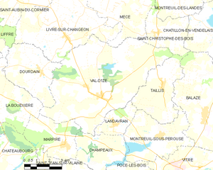
Val-d'Izé
- commune in Ille-et-Vilaine, France
- Country:
- Postal Code: 35450
- Coordinates: 48° 10' 38" N, 1° 18' 17" E
- GPS tracks (wikiloc): [Link]
- Area: 43.79 sq km
- Population: 2588
- Web site: [Link]


Saint-Aubin-du-Cormier
- commune in Ille-et-Vilaine, France
- Country:
- Postal Code: 35140
- Coordinates: 48° 15' 30" N, 1° 24' 9" E
- GPS tracks (wikiloc): [Link]
- Area: 27.41 sq km
- Population: 3732
- Web site: [Link]


Mecé
- commune in Ille-et-Vilaine, France
- Country:
- Postal Code: 35450
- Coordinates: 48° 14' 14" N, 1° 18' 9" E
- GPS tracks (wikiloc): [Link]
- AboveSeaLevel: 120 м m
- Area: 15.63 sq km
- Population: 601
- Web site: [Link]