Longvillers (Longvillers)

- commune in Calvados, France
- Country:

- Postal Code: 14310
- Coordinates: 49° 3' 6" N, 0° 37' 52" E


- GPS tracks (wikiloc): [Link]
- Area: 6.65 sq km
- Population: 363
- Wikipedia en: wiki(en)
- Wikipedia: wiki(fr)
- Wikidata storage: Wikidata: Q844438
- Wikipedia Commons Category: [Link]
- Freebase ID: [/m/03075h]
- Freebase ID: [/m/03075h]
- GeoNames ID: Alt: [6427296]
- GeoNames ID: Alt: [6427296]
- SIREN number: [211403795]
- SIREN number: [211403795]
- BnF ID: [15247793g]
- BnF ID: [15247793g]
- VIAF ID: Alt: [236157639]
- VIAF ID: Alt: [236157639]
- INSEE municipality code: 14379
- INSEE municipality code: 14379
Shares border with regions:


Saint-Georges-d'Aunay
- former commune in Calvados, France
- Country:
- Postal Code: 14260
- Coordinates: 49° 2' 13" N, 0° 40' 52" E
- GPS tracks (wikiloc): [Link]
- Area: 23.51 sq km
- Population: 717
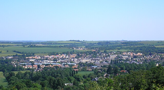
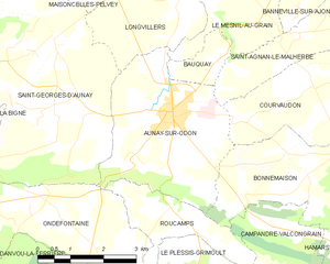
Aunay-sur-Odon
- former commune in Calvados, France
- Country:
- Postal Code: 14260
- Coordinates: 49° 1' 13" N, 0° 37' 55" E
- GPS tracks (wikiloc): [Link]
- Area: 12.74 sq km
- Population: 3263


Maisoncelles-Pelvey
- commune in Calvados, France
- Country:
- Postal Code: 14310
- Coordinates: 49° 3' 25" N, 0° 40' 27" E
- GPS tracks (wikiloc): [Link]
- Area: 5.4 sq km
- Population: 262


Le Mesnil-au-Grain
- commune in Calvados, France
- Country:
- Postal Code: 14260
- Coordinates: 49° 2' 40" N, 0° 35' 59" E
- GPS tracks (wikiloc): [Link]
- Area: 4.3 sq km
- Population: 72

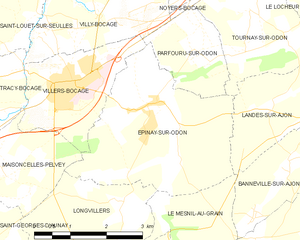
Épinay-sur-Odon
- commune in Calvados, France
- Country:
- Postal Code: 14310
- Coordinates: 49° 4' 35" N, 0° 37' 16" E
- GPS tracks (wikiloc): [Link]
- Area: 11.58 sq km
- Population: 626