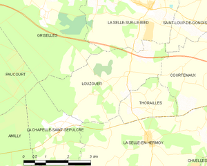
Louzouer (Louzouer)
- commune in Loiret, France
- Country:

- Postal Code: 45210
- Coordinates: 48° 2' 17" N, 2° 52' 53" E


- GPS tracks (wikiloc): [Link]
- Area: 11.23 sq km
- Population: 291
- Wikipedia en: wiki(en)
- Wikipedia: wiki(fr)
- Wikidata storage: Wikidata: Q1391668
- Wikipedia Commons Category: [Link]
- Freebase ID: [/m/03nwjm0]
- GeoNames ID: Alt: [6434638]
- SIREN number: [214501892]
- BnF ID: [15260581n]
- INSEE municipality code: 45189
Shares border with regions:


La Chapelle-Saint-Sépulcre
- commune in Loiret, France
- Country:

- Postal Code: 45210
- Coordinates: 48° 1' 4" N, 2° 50' 40" E


- GPS tracks (wikiloc): [Link]
- Area: 6.21 sq km
- Population: 244


Courtemaux
- commune in Loiret, France
- Country:

- Postal Code: 45320
- Coordinates: 48° 3' 1" N, 2° 56' 3" E


- GPS tracks (wikiloc): [Link]
- Area: 12.19 sq km
- Population: 270


La Selle-en-Hermoy
- commune in Loiret, France
- Country:

- Postal Code: 45210
- Coordinates: 48° 0' 39" N, 2° 53' 39" E


- GPS tracks (wikiloc): [Link]
- Area: 19.56 sq km
- Population: 843


Thorailles
- commune in Loiret, France
- Country:

- Postal Code: 45210
- Coordinates: 48° 1' 24" N, 2° 53' 53" E


- GPS tracks (wikiloc): [Link]
- Area: 3.45 sq km
- Population: 178


Saint-Loup-de-Gonois
- commune in Loiret, France
- Country:

- Postal Code: 45210
- Coordinates: 48° 3' 32" N, 2° 55' 15" E


- GPS tracks (wikiloc): [Link]
- Area: 6.16 sq km
- Population: 89


Griselles
- commune in Loiret, France
- Country:

- Postal Code: 45210
- Coordinates: 48° 4' 43" N, 2° 49' 45" E


- GPS tracks (wikiloc): [Link]
- Area: 30.32 sq km
- Population: 804


La Selle-sur-le-Bied
- commune in Loiret, France
- Country:

- Postal Code: 45210
- Coordinates: 48° 3' 53" N, 2° 53' 42" E


- GPS tracks (wikiloc): [Link]
- Area: 23.96 sq km
- Population: 1051
- Web site: [Link]
