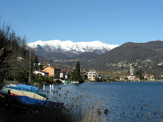
Magliaso (Magliaso)
- municipality in the canton of Ticino, Switzerland
Magliaso is a picturesque village located in the Italian-speaking region of Switzerland, specifically in the canton of Ticino. Nestled near Lake Lugano, it offers stunning views and a variety of hiking opportunities that cater to different skill levels. Here are some highlights of hiking in and around Magliaso:
Trails and Routes
-
Monte Brè Trail: A popular hike that begins in Lugano and leads up to Monte Brè. The trail offers breathtaking views of the surrounding mountains and Lake Lugano. It's a moderate hike, and you can also take the funicular for part of the journey.
-
Sentiero di Gandria: This scenic trail runs from Lugano to Gandria, hugging the lakeshore and passing through lush vegetation and charming villages. The path is relatively easy and perfect for a leisurely hike.
-
Parco Ciani: Close to Magliaso, this park provides several well-marked trails. The area is perfect for family hikes, and the shaded paths make for a pleasant walk, especially during warm weather.
-
Lugano to Caprino: This is a more challenging hike that takes you up into the hills with rewarding views over the lake and the city of Lugano.
Flora and Fauna
The region around Magliaso features a diverse range of flora and fauna. You'll encounter Mediterranean plants, beautiful forests, and potential sightings of local wildlife, such as deer and various bird species.
Best Time to Hike
The best time to hike in Magliaso is during the spring (April to June) and autumn (September to October) when the weather is mild and the landscapes are particularly beautiful, with wildflowers blooming in the spring and stunning fall colors.
Safety and Recommendations
- Always check the weather conditions before heading out, as mountain weather can be unpredictable.
- Carry sufficient water, snacks, and a map or GPS device.
- Wear appropriate hiking boots and clothing based on the season.
Conclusion
Whether you're looking for a leisurely stroll along the lake or a more demanding mountain hike, Magliaso and its surroundings offer something for everyone. Always remember to respect nature and the local trails by following Leave No Trace principles. Happy hiking!
- Country:

- Postal Code: 6983
- Local Dialing Code: 091
- Licence Plate Code: TI
- Coordinates: 45° 59' 1" N, 8° 53' 18" E


- GPS tracks (wikiloc): [Link]
- AboveSeaLevel: 287 м m
- Area: 1.1 sq km
- Population: 1607
- Web site: http://www.magliaso.ch
- Wikipedia en: wiki(en)
- Wikipedia: wiki(de)
- Wikidata storage: Wikidata: Q70159
- Wikipedia Commons Category: [Link]
- Freebase ID: [/m/0gzs17]
- GeoNames ID: Alt: [6559637]
- VIAF ID: Alt: [126917631]
- OSM relation ID: [1684704]
- GND ID: Alt: [4403940-2]
- Library of Congress authority ID: Alt: [nb2004302361]
- HDS ID: [2178]
- Swiss municipality code: [5193]
Shares border with regions:


Agno
- municipality in the canton of Ticino, Switzerland
Agno, located in the canton of Ticino in Switzerland, offers beautiful hiking opportunities amidst stunning natural landscapes. The region is characterized by its picturesque views of Lake Lugano, lush greenery, and the surrounding mountains, making it an ideal destination for both casual walkers and experienced hikers....
- Country:

- Postal Code: 6982
- Local Dialing Code: 091
- Licence Plate Code: TI
- Coordinates: 46° 0' 1" N, 8° 54' 0" E


- GPS tracks (wikiloc): [Link]
- AboveSeaLevel: 286 м m
- Area: 2.5 sq km
- Population: 4480
- Web site: [Link]


Caslano
- municipality in the canton of Ticino, Switzerland
Caslano is a charming village located in the canton of Ticino in southern Switzerland, nestled between Lake Lugano and the surrounding mountains. It offers a range of hiking opportunities that cater to different skill levels, making it a delightful destination for hikers and nature enthusiasts....
- Country:

- Postal Code: 6987
- Local Dialing Code: 091
- Licence Plate Code: TI
- Coordinates: 45° 58' 12" N, 8° 52' 46" E


- GPS tracks (wikiloc): [Link]
- AboveSeaLevel: 291 м m
- Area: 2.78 sq km
- Population: 4330
- Web site: [Link]
Pura
- municipality in the canton of Ticino, Switzerland
Pura, a charming village in the Canton of Ticino, Switzerland, offers a picturesque setting for hiking enthusiasts. Nestled along the shores of Lake Lugano and surrounded by the stunning Swiss Alps, Pura provides a variety of hiking trails that cater to different skill levels....
- Country:

- Postal Code: 6984
- Local Dialing Code: 091
- Licence Plate Code: TI
- Coordinates: 45° 59' 0" N, 8° 52' 0" E


- GPS tracks (wikiloc): [Link]
- AboveSeaLevel: 387 м m
- Area: 3.1 sq km
- Population: 1364
- Web site: [Link]


Collina d'Oro
- municipality in the canton of Ticino, Switzerland
Collina d'Oro, located in the Canton of Ticino in Switzerland, is a beautiful destination for hiking enthusiasts. This region, known for its picturesque landscapes, offers a variety of trails that cater to different skill levels, making it an ideal spot for both novice and experienced hikers....
- Country:

- Postal Code: 6926
- Local Dialing Code: 091
- Licence Plate Code: TI
- Coordinates: 45° 59' 0" N, 8° 55' 0" E


- GPS tracks (wikiloc): [Link]
- AboveSeaLevel: 469 м m
- Area: 6.91 sq km
- Population: 4911
- Web site: [Link]
Neggio
- municipality in the canton of Ticino, Switzerland
Neggio is a charming village located in the Swiss canton of Ticino, near Lake Lugano. It's a great place for hiking enthusiasts, offering beautiful landscapes, lush forests, and stunning views of the surrounding mountains and valleys. Here are some insights into hiking in Neggio:...
- Country:

- Postal Code: 6991
- Local Dialing Code: 091
- Licence Plate Code: TI
- Coordinates: 45° 59' 21" N, 8° 52' 40" E


- GPS tracks (wikiloc): [Link]
- AboveSeaLevel: 428 м m
- Area: 0.9 sq km
- Population: 317
- Web site: [Link]

