
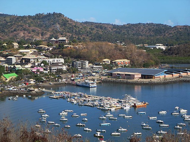
Mayotte (Mayotte)
.svg)
- overseas department and region of France
- Country:

- Capital: Mamoudzou
- Licence Plate Code: 976
- Coordinates: 12° 50' 35" S, 45° 8' 18" W


- GPS tracks (wikiloc): [Link]
- Area: 374.0 sq km
- Population: 256518
- Web site: http://www.mayotte.pref.gouv.fr/
- Wikipedia en: wiki(en)
- Wikipedia: wiki(fr)
- Wikidata storage: Wikidata: Q17063
- Wikipedia Commons Gallery: [Link]
- Wikipedia Commons Category: [Link]
- Wikipedia Commons Maps Category: [Link]
- Freebase ID: [/m/04vws]
- GeoNames ID: Alt: [1024031]
- VIAF ID: Alt: [312738295]
- OSM relation ID: [3388394]
- GND ID: Alt: [6106489-0]
- archINFORM location ID: [6157]
- Library of Congress authority ID: Alt: [n81141395]
- MusicBrainz area ID: [00ff2645-3ec9-36d6-9ea9-757363641c83]
- Quora topic ID: [Mayotte]
- TGN ID: [7001669]
- Encyclopædia Britannica Online ID: [place/Mayotte]
- Gran Enciclopèdia Catalana ID: [0041571]
- Encyclopædia Universalis ID: [mayotte]
- ISNI: Alt: [0000 0001 2175 4969]
- NKCR AUT ID: [ge570803]
- DMOZ ID: Alt: [Regional/Africa/Mayotte/]
- NUTS code: [FRA50]
- BabelNet ID: [01192881n]
- INSEE department code: [976]
- LoC and MARC vocabularies ID: [countries/ot]
- INSEE region code: [06]
- Statoids ID: [uyt]
- Le Monde diplomatique subject ID: [pays/mayotte]
- UNESCO Thesaurus ID: [concept723]
- Invasive Species Compendium Datasheet ID: [108611]
- NYT topic ID: [destination/mayotte]
- ISO 3166-2 code: FR-YT
- FIPS 10-4 (countries and regions): MF
- GACS ID: 478
- ISO 3166-1 alpha-2 code: YT
- ISO 3166-1 alpha-3 code: MYT
- ISO 3166-1 numeric code: 175
Includes regions:

Pamandzi
- commune in Mayotte, France
- Country:
- Postal Code: 97610
- Coordinates: 12° 47' 48" S, 45° 16' 46" W
- GPS tracks (wikiloc): [Link]
- AboveSeaLevel: 23 м m
- Area: 4.24 sq km
- Population: 11442
- Web site: [Link]
Mamoudzou
- commune in Mayotte, France
- Country:
- Postal Code: 97600
- Coordinates: 12° 46' 56" S, 45° 13' 44" W
- GPS tracks (wikiloc): [Link]
- AboveSeaLevel: 23 м m
- Area: 42.3 sq km
- Population: 71437
- Web site: [Link]
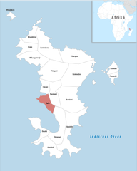
Sada
- commune in Mayotte, France
- Country:
- Postal Code: 97640
- Coordinates: 12° 50' 56" S, 45° 5' 59" W
- GPS tracks (wikiloc): [Link]
- Area: 10.26 sq km
- Population: 11156


Acoua
- commune in Mayotte, France
- Country:
- Postal Code: 97630
- Coordinates: 12° 43' 19" S, 45° 3' 24" W
- GPS tracks (wikiloc): [Link]
- AboveSeaLevel: 371 м m
- Area: 13.11 sq km
- Population: 5192

Chirongui
- commune in Mayotte, France
- Country:
- Postal Code: 97620
- Coordinates: 12° 55' 55" S, 45° 8' 54" W
- GPS tracks (wikiloc): [Link]
- AboveSeaLevel: 13 м m
- Area: 28.76 sq km
- Population: 8920

Chiconi
- commune in Mayotte, France
- Country:
- Postal Code: 97670
- Coordinates: 12° 50' 0" S, 45° 6' 38" W
- GPS tracks (wikiloc): [Link]
- AboveSeaLevel: 109 м m
- Area: 8.51 sq km
- Population: 8295
- Web site: [Link]

Tsingoni
- commune in Mayotte, France
- Country:
- Postal Code: 97680
- Coordinates: 12° 47' 15" S, 45° 6' 10" W
- GPS tracks (wikiloc): [Link]
- Area: 34.42 sq km
- Population: 13934
Dembeni
- commune in Mayotte, France
- Country:
- Postal Code: 97660
- Coordinates: 12° 50' 37" S, 45° 11' 6" W
- GPS tracks (wikiloc): [Link]
- AboveSeaLevel: 20 м m
- Area: 38.38 sq km
- Population: 15848

Bouéni
- commune in Mayotte, France
- Country:
- Postal Code: 97620
- Coordinates: 12° 54' 25" S, 45° 4' 43" W
- GPS tracks (wikiloc): [Link]
- AboveSeaLevel: 290 м m
- Area: 14.29 sq km
- Population: 6189


Kani-Kéli
- commune in Mayotte, France
- Country:
- Postal Code: 97625
- Coordinates: 12° 57' 24" S, 45° 6' 18" W
- GPS tracks (wikiloc): [Link]
- AboveSeaLevel: 308 м m
- Area: 20.59 sq km
- Population: 5507

Bandrele
- commune in Mayotte, France
- Country:
- Postal Code: 97620
- Coordinates: 12° 54' 32" S, 45° 11' 40" W
- GPS tracks (wikiloc): [Link]
- AboveSeaLevel: 384 м m
- Area: 36.56 sq km
- Population: 10282


canton of Bandraboua
- canton of France
- Country:
- Capital: Bandraboua
- Coordinates: 12° 43' 31" S, 45° 6' 26" W
- GPS tracks (wikiloc): [Link]
- Population: 19883

canton of Bouéni
- canton of France
- Country:
- Capital: Bouéni
- Coordinates: 12° 54' 45" S, 45° 6' 6" W
- GPS tracks (wikiloc): [Link]
- Population: 15056

canton of Dembeni
- canton of France
- Country:
- Capital: Dembeni
- Coordinates: 12° 50' 14" S, 45° 10' 33" W
- GPS tracks (wikiloc): [Link]
- Population: 22770


canton of Dzaoudzi
- canton of France
- Country:
- Capital: Dzaoudzi
- Coordinates: 12° 47' 24" S, 45° 16' 50" W
- GPS tracks (wikiloc): [Link]
- Population: 17831

canton of Koungou
- canton of France
- Country:
- Capital: Koungou
- Coordinates: 12° 44' 19" S, 45° 12' 26" W
- GPS tracks (wikiloc): [Link]
- Population: 23129
canton of M'tsangamouji
- canton of France
- Country:
- Capital: M'Tsangamouji
- Coordinates: 12° 45' 35" S, 45° 4' 58" W
- GPS tracks (wikiloc): [Link]


canton of Mamoudzou-1
- canton of France
- Country:
- Capital: Mamoudzou
- Coordinates: 12° 48' 20" S, 45° 11' 24" W
- GPS tracks (wikiloc): [Link]
- Population: 22626


canton of Mtsamboro
- canton of France
- Country:
- Capital: Mtsamboro
- Coordinates: 12° 42' 0" S, 45° 4' 16" W
- GPS tracks (wikiloc): [Link]
- Population: 16030
canton of Ouangani
- canton of France
- Country:
- Capital: Ouangani
- Coordinates: 12° 50' 55" S, 45° 8' 41" W
- GPS tracks (wikiloc): [Link]
- Population: 18498

canton of Pamandzi
- canton of France
- Country:
- Capital: Pamandzi
- Coordinates: 12° 47' 47" S, 45° 16' 25" W
- GPS tracks (wikiloc): [Link]
- Population: 11442

canton of Sada
- canton of France
- Country:
- Capital: Sada
- Coordinates: 12° 51' 4" S, 45° 5' 59" W
- GPS tracks (wikiloc): [Link]
- Population: 20076

canton of Tsingoni
- canton of France
- Country:
- Capital: Tsingoni
- Coordinates: 12° 47' 9" S, 45° 6' 41" W
- GPS tracks (wikiloc): [Link]
- Population: 20366
Ouangani
- commune in Mayotte, France
- Country:
- Postal Code: 97670
- Coordinates: 12° 50' 57" S, 45° 8' 20" W
- GPS tracks (wikiloc): [Link]
- AboveSeaLevel: 105 м m
- Area: 18.5 sq km
- Population: 10203

Bandraboua
- commune in Mayotte, France
- Country:
- Capital: Bandraboua
- Postal Code: 97650
- Coordinates: 12° 42' 7" S, 45° 7' 12" W
- GPS tracks (wikiloc): [Link]
- AboveSeaLevel: 301 м m
- Area: 32.11 sq km
- Population: 13989
Mtsamboro
- commune in Mayotte, France
- Country:
- Postal Code: 97630
- Coordinates: 12° 41' 59" S, 45° 4' 8" W
- GPS tracks (wikiloc): [Link]
- AboveSeaLevel: 26 м m
- Area: 16.41 sq km
- Population: 7705
- Web site: [Link]
Koungou
- commune in Mayotte, France
- Country:
- Postal Code: 97600
- Coordinates: 12° 44' 1" S, 45° 12' 15" W
- GPS tracks (wikiloc): [Link]
- AboveSeaLevel: 40 м m
- Area: 28.43 sq km
- Population: 32156
- Web site: [Link]
Dzaoudzi
- commune in Mayotte, France
- Country:
- Postal Code: 97615
- Coordinates: 12° 47' 18" S, 45° 16' 21" W
- GPS tracks (wikiloc): [Link]
- Area: 7.87 sq km
- Population: 17831
M'Tsangamouji
- commune in Mayotte, France
- Country:
- Postal Code: 97650
- Coordinates: 12° 45' 34" S, 45° 5' 1" W
- GPS tracks (wikiloc): [Link]
- AboveSeaLevel: 57 м m
- Area: 22.04 sq km
- Population: 6432
- Web site: [Link]