Monestier-Port-Dieu (Monestier-Port-Dieu)

- commune in Corrèze, France
- Country:

- Postal Code: 19110
- Coordinates: 45° 29' 35" N, 2° 30' 5" E


- GPS tracks (wikiloc): [Link]
- Area: 18 sq km
- Population: 113
- Wikipedia en: wiki(en)
- Wikipedia: wiki(fr)
- Wikidata storage: Wikidata: Q624320
- Wikipedia Commons Category: [Link]
- Freebase ID: [/m/03mfz_9]
- GeoNames ID: Alt: [6428375]
- SIREN number: [211914205]
- BnF ID: [152497782]
- VIAF ID: Alt: [141178464]
- Library of Congress authority ID: Alt: [nr98035391]
- PACTOLS thesaurus ID: [pcrtRsjSzPMF3D]
- Trismegistos Geo ID: [23185]
- INSEE municipality code: 19142
Shares border with regions:


Labessette
- commune in Puy-de-Dôme, France
- Country:
- Postal Code: 63690
- Coordinates: 45° 29' 21" N, 2° 32' 15" E
- GPS tracks (wikiloc): [Link]
- Area: 10.45 sq km
- Population: 61

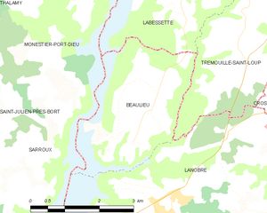
Beaulieu
- commune in Cantal, France
- Country:
- Postal Code: 15270
- Coordinates: 45° 27' 24" N, 2° 30' 43" E
- GPS tracks (wikiloc): [Link]
- AboveSeaLevel: 620 м m
- Area: 7.64 sq km
- Population: 90


Confolent-Port-Dieu
- commune in Corrèze, France
- Country:
- Postal Code: 19200
- Coordinates: 45° 32' 36" N, 2° 29' 47" E
- GPS tracks (wikiloc): [Link]
- Area: 8.47 sq km
- Population: 38
- Web site: [Link]
Thalamy
- commune in Corrèze, France
- Country:
- Postal Code: 19200
- Coordinates: 45° 30' 48" N, 2° 27' 34" E
- GPS tracks (wikiloc): [Link]
- Area: 11.84 sq km
- Population: 98

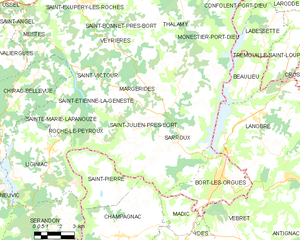
Saint-Julien-près-Bort
- former commune in Corrèze, France
- Country:
- Postal Code: 19110
- Coordinates: 45° 24' 57" N, 2° 24' 8" E
- GPS tracks (wikiloc): [Link]
- Area: 30.63 sq km
- Population: 404


Larodde
- commune in Puy-de-Dôme, France
- Country:
- Postal Code: 63690
- Coordinates: 45° 31' 33" N, 2° 33' 0" E
- GPS tracks (wikiloc): [Link]
- Area: 23.04 sq km
- Population: 267

Sarroux
- former commune in Corrèze, France
- Country:
- Postal Code: 19110
- Coordinates: 45° 24' 51" N, 2° 25' 48" E
- GPS tracks (wikiloc): [Link]
- Area: 23.76 sq km
- Population: 432
- Web site: [Link]