Monségur (Monségur)

- commune in Lot-et-Garonne, France
- Country:

- Postal Code: 47150
- Coordinates: 44° 29' 2" N, 0° 52' 45" E


- GPS tracks (wikiloc): [Link]
- AboveSeaLevel: 236 м m
- Area: 10.99 sq km
- Population: 398
- Wikipedia en: wiki(en)
- Wikipedia: wiki(fr)
- Wikidata storage: Wikidata: Q589475
- Wikipedia Commons Category: [Link]
- Freebase ID: [/m/03qf44f]
- GeoNames ID: Alt: [6616873]
- SIREN number: [214701781]
- INSEE municipality code: 47178
Shares border with regions:


Condezaygues
- commune in Lot-et-Garonne, France
- Country:
- Postal Code: 47500
- Coordinates: 44° 29' 13" N, 0° 55' 0" E
- GPS tracks (wikiloc): [Link]
- Area: 10.81 sq km
- Population: 854


Trentels
- commune in Lot-et-Garonne, France
- Country:
- Postal Code: 47140
- Coordinates: 44° 26' 8" N, 0° 51' 46" E
- GPS tracks (wikiloc): [Link]
- Area: 19.47 sq km
- Population: 832

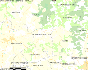
Montagnac-sur-Lède
- commune in Lot-et-Garonne, France
- Country:
- Postal Code: 47150
- Coordinates: 44° 32' 30" N, 0° 50' 39" E
- GPS tracks (wikiloc): [Link]
- Area: 19.55 sq km
- Population: 258


Lacaussade
- commune in Lot-et-Garonne, France
- Country:
- Postal Code: 47150
- Coordinates: 44° 30' 22" N, 0° 49' 32" E
- GPS tracks (wikiloc): [Link]
- Area: 10.28 sq km
- Population: 219

Saint-Aubin
- commune in Lot-et-Garonne, France
- Country:
- Postal Code: 47150
- Coordinates: 44° 28' 34" N, 0° 51' 9" E
- GPS tracks (wikiloc): [Link]
- AboveSeaLevel: 144 м m
- Area: 18.51 sq km
- Population: 441


Salles
- commune in Lot-et-Garonne, France
- Country:
- Postal Code: 47150
- Coordinates: 44° 32' 57" N, 0° 52' 16" E
- GPS tracks (wikiloc): [Link]
- AboveSeaLevel: 101 м m
- Area: 21.58 sq km
- Population: 288