Mons-en-Pévèle (Mons-en-Pévèle)

- commune in Nord, France
- Country:

- Postal Code: 59246
- Coordinates: 50° 28' 46" N, 3° 6' 8" E


- GPS tracks (wikiloc): [Link]
- AboveSeaLevel: 107 м m
- Area: 12.37 sq km
- Population: 2121
- Wikipedia en: wiki(en)
- Wikipedia: wiki(fr)
- Wikidata storage: Wikidata: Q744082
- Wikipedia Commons Category: [Link]
- Freebase ID: [/m/03h2y6v]
- Freebase ID: [/m/03h2y6v]
- GeoNames ID: Alt: [6438371]
- GeoNames ID: Alt: [6438371]
- SIREN number: [215904111]
- SIREN number: [215904111]
- BnF ID: [15266983w]
- BnF ID: [15266983w]
- VIAF ID: Alt: [159603981]
- VIAF ID: Alt: [159603981]
- Library of Congress authority ID: Alt: [n95019158]
- Library of Congress authority ID: Alt: [n95019158]
- INSEE municipality code: 59411
- INSEE municipality code: 59411
Shares border with regions:

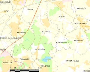
Attiches
- commune in Nord, France
- Country:
- Postal Code: 59551
- Coordinates: 50° 31' 21" N, 3° 3' 40" E
- GPS tracks (wikiloc): [Link]
- Area: 6.68 sq km
- Population: 2260
- Web site: [Link]


Moncheaux
- commune in Nord, France
- Country:
- Postal Code: 59283
- Coordinates: 50° 27' 11" N, 3° 4' 46" E
- GPS tracks (wikiloc): [Link]
- Area: 4.97 sq km
- Population: 1486


Bersée
- commune in Nord, France
- Country:
- Postal Code: 59235
- Coordinates: 50° 28' 55" N, 3° 8' 41" E
- GPS tracks (wikiloc): [Link]
- Area: 10.93 sq km
- Population: 2209
- Web site: [Link]
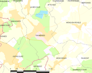
Thumeries
- commune in Nord, France
- Country:
- Postal Code: 59239
- Coordinates: 50° 28' 44" N, 3° 3' 18" E
- GPS tracks (wikiloc): [Link]
- Area: 7.03 sq km
- Population: 3942


Mérignies
- commune in Nord, France
- Country:
- Postal Code: 59710
- Coordinates: 50° 30' 20" N, 3° 6' 36" E
- GPS tracks (wikiloc): [Link]
- Area: 8.61 sq km
- Population: 2898
- Web site: [Link]


Tourmignies
- commune in Nord, France
- Country:
- Postal Code: 59551
- Coordinates: 50° 30' 24" N, 3° 5' 3" E
- GPS tracks (wikiloc): [Link]
- Area: 2.03 sq km
- Population: 867
- Web site: [Link]


Faumont
- commune in Nord, France
- Country:
- Postal Code: 59310
- Coordinates: 50° 27' 38" N, 3° 8' 17" E
- GPS tracks (wikiloc): [Link]
- Area: 9.58 sq km
- Population: 2150
- Web site: [Link]