Mont-Dol (Mont-Dol)

- commune in Ille-et-Vilaine, France
- Country:

- Postal Code: 35120
- Coordinates: 48° 34' 11" N, 1° 45' 57" E


- GPS tracks (wikiloc): [Link]
- Area: 26.44 sq km
- Population: 1121
- Web site: http://www.mont-dol.fr
- Wikipedia en: wiki(en)
- Wikipedia: wiki(fr)
- Wikidata storage: Wikidata: Q624136
- Wikipedia Commons Category: [Link]
- Freebase ID: [/m/03m9pzj]
- Freebase ID: [/m/03m9pzj]
- GeoNames ID: Alt: [2992756]
- GeoNames ID: Alt: [2992756]
- SIREN number: [213501869]
- SIREN number: [213501869]
- BnF ID: [15257129x]
- BnF ID: [15257129x]
- OSM relation ID: [906818]
- OSM relation ID: [906818]
- INSEE municipality code: 35186
- INSEE municipality code: 35186
Shares border with regions:


Baguer-Pican
- commune in Ille-et-Vilaine, France
- Country:
- Postal Code: 35120
- Coordinates: 48° 33' 9" N, 1° 41' 57" E
- GPS tracks (wikiloc): [Link]
- Area: 15.63 sq km
- Population: 1641

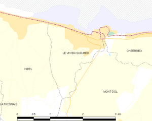
Le Vivier-sur-Mer
- commune in Ille-et-Vilaine, France
- Country:
- Postal Code: 35960
- Coordinates: 48° 36' 8" N, 1° 46' 27" E
- GPS tracks (wikiloc): [Link]
- Area: 2.24 sq km
- Population: 1049
- Web site: [Link]


Cherrueix
- commune in Ille-et-Vilaine, France
- Country:
- Postal Code: 35120
- Coordinates: 48° 36' 18" N, 1° 42' 39" E
- GPS tracks (wikiloc): [Link]
- Area: 12.69 sq km
- Population: 1132
- Web site: [Link]


Dol-de-Bretagne
- commune in Ille-et-Vilaine, France
- Country:
- Postal Code: 35120
- Coordinates: 48° 32' 59" N, 1° 45' 3" E
- GPS tracks (wikiloc): [Link]
- AboveSeaLevel: 16 м m
- Area: 15.53 sq km
- Population: 5646
- Web site: [Link]


Roz-Landrieux
- commune in Ille-et-Vilaine, France
- Country:
- Postal Code: 35120
- Coordinates: 48° 32' 36" N, 1° 48' 57" E
- GPS tracks (wikiloc): [Link]
- Area: 18.1 sq km
- Population: 1337

Hirel
- commune in Ille-et-Vilaine, France
- Country:
- Postal Code: 35120
- Coordinates: 48° 36' 20" N, 1° 48' 6" E
- GPS tracks (wikiloc): [Link]
- Area: 9.85 sq km
- Population: 1368
- Web site: [Link]


La Fresnais
- commune in Ille-et-Vilaine, France
- Country:
- Postal Code: 35111
- Coordinates: 48° 35' 44" N, 1° 50' 36" E
- GPS tracks (wikiloc): [Link]
- Area: 14.43 sq km
- Population: 2460