Montazeau (Montazeau)

- commune in Dordogne, France
- Country:

- Postal Code: 24230
- Coordinates: 44° 53' 34" N, 0° 7' 48" E


- GPS tracks (wikiloc): [Link]
- Area: 13.78 sq km
- Population: 305
- Wikipedia en: wiki(en)
- Wikipedia: wiki(fr)
- Wikidata storage: Wikidata: Q205009
- Wikipedia Commons Category: [Link]
- Freebase ID: [/m/03ln6s]
- Freebase ID: [/m/03ln6s]
- GeoNames ID: Alt: [2992958]
- GeoNames ID: Alt: [2992958]
- SIREN number: [212402887]
- SIREN number: [212402887]
- BnF ID: [152519348]
- BnF ID: [152519348]
- INSEE municipality code: 24288
- INSEE municipality code: 24288
Shares border with regions:

Nastringues
- commune in Dordogne, France
- Country:
- Postal Code: 24230
- Coordinates: 44° 52' 30" N, 0° 9' 14" E
- GPS tracks (wikiloc): [Link]
- Area: 6.22 sq km
- Population: 103

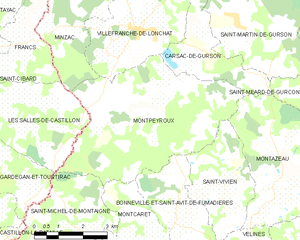
Montpeyroux
- commune in Dordogne, France
- Country:
- Postal Code: 24610
- Coordinates: 44° 55' 12" N, 0° 3' 25" E
- GPS tracks (wikiloc): [Link]
- Area: 23.37 sq km
- Population: 447

Carsac-de-Gurson
- commune in Dordogne, France
- Country:
- Postal Code: 24610
- Coordinates: 44° 56' 49" N, 0° 5' 25" E
- GPS tracks (wikiloc): [Link]
- Area: 6.91 sq km
- Population: 199