Montigny-sur-l'Hallue (Montigny-sur-l'Hallue)

- commune in Somme, France
- Country:

- Postal Code: 80260
- Coordinates: 49° 58' 47" N, 2° 26' 35" E


- GPS tracks (wikiloc): [Link]
- Area: 4.91 sq km
- Population: 216
- Wikipedia en: wiki(en)
- Wikipedia: wiki(fr)
- Wikidata storage: Wikidata: Q429120
- Wikipedia Commons Category: [Link]
- Freebase ID: [/m/03qm823]
- GeoNames ID: Alt: [2992388]
- SIREN number: [218005320]
- BnF ID: [15277039c]
- INSEE municipality code: 80562
Shares border with regions:

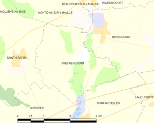
Fréchencourt
- commune in Somme, France
- Country:
- Postal Code: 80260
- Coordinates: 49° 57' 56" N, 2° 26' 28" E
- GPS tracks (wikiloc): [Link]
- Area: 5.59 sq km
- Population: 270


Mirvaux
- commune in Somme, France
- Country:
- Postal Code: 80260
- Coordinates: 50° 0' 10" N, 2° 23' 42" E
- GPS tracks (wikiloc): [Link]
- Area: 2.29 sq km
- Population: 150

Molliens-au-Bois
- commune in Somme, France
- Country:
- Postal Code: 80260
- Coordinates: 49° 59' 18" N, 2° 23' 7" E
- GPS tracks (wikiloc): [Link]
- Area: 7.28 sq km
- Population: 324

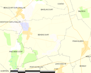
Béhencourt
- commune in Somme, France
- Country:
- Postal Code: 80260
- Coordinates: 49° 58' 29" N, 2° 27' 10" E
- GPS tracks (wikiloc): [Link]
- Area: 7.06 sq km
- Population: 337


Beaucourt-sur-l'Hallue
- commune in Somme, France
- Country:
- Postal Code: 80260
- Coordinates: 49° 59' 14" N, 2° 26' 41" E
- GPS tracks (wikiloc): [Link]
- Area: 5.47 sq km
- Population: 284


Saint-Gratien
- commune in Somme, France
- Country:
- Postal Code: 80260
- Coordinates: 49° 57' 57" N, 2° 24' 31" E
- GPS tracks (wikiloc): [Link]
- Area: 6.95 sq km
- Population: 374