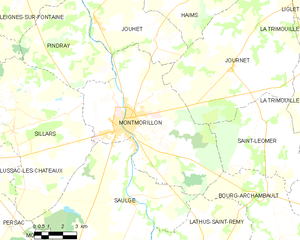
Montmorillon (Montmorillon)
- commune in Vienne, France
- Country:

- Postal Code: 86500
- Coordinates: 46° 25' 34" N, 0° 52' 15" E


- GPS tracks (wikiloc): [Link]
- Area: 57 sq km
- Population: 6095
- Web site: http://www.montmorillon.fr
- Wikipedia en: wiki(en)
- Wikipedia: wiki(fr)
- Wikidata storage: Wikidata: Q476242
- Wikipedia Commons Category: [Link]
- Freebase ID: [/m/08shj0]
- GeoNames ID: Alt: [2992225]
- SIREN number: [218601656]
- BnF ID: [15278592f]
- VIAF ID: Alt: [140683766]
- GND ID: Alt: [4365002-8]
- Library of Congress authority ID: Alt: [n00037256]
- Quora topic ID: [Montmorillon]
- NKCR AUT ID: [ge959624]
- INSEE municipality code: 86165
Shares border with regions:


Bourg-Archambault
- commune in Vienne, France
- Country:

- Postal Code: 86390
- Coordinates: 46° 22' 57" N, 1° 0' 12" E


- GPS tracks (wikiloc): [Link]
- Area: 24.33 sq km
- Population: 191


Pindray
- commune in Vienne, France
- Country:

- Postal Code: 86500
- Coordinates: 46° 29' 28" N, 0° 48' 43" E


- GPS tracks (wikiloc): [Link]
- Area: 26.74 sq km
- Population: 261


Saint-Léomer
- commune in Vienne, France
- Country:

- Postal Code: 86290
- Coordinates: 46° 26' 11" N, 0° 59' 39" E


- GPS tracks (wikiloc): [Link]
- Area: 28.67 sq km
- Population: 183


Journet
- commune in Vienne, France
- Country:

- Postal Code: 86290
- Coordinates: 46° 27' 49" N, 0° 58' 4" E


- GPS tracks (wikiloc): [Link]
- Area: 58.51 sq km
- Population: 364


Saulgé
- commune in Vienne, France
- Country:

- Postal Code: 86500
- Coordinates: 46° 22' 40" N, 0° 52' 33" E


- GPS tracks (wikiloc): [Link]
- Area: 62.31 sq km
- Population: 1019


Lathus-Saint-Rémy
- commune in Vienne, France
- Country:

- Postal Code: 86390
- Coordinates: 46° 20' 1" N, 0° 57' 31" E


- GPS tracks (wikiloc): [Link]
- AboveSeaLevel: 180 м m
- Area: 98.28 sq km
- Population: 1216
Sillars
- commune in Vienne, France
- Country:

- Postal Code: 86320
- Coordinates: 46° 25' 6" N, 0° 46' 9" E


- GPS tracks (wikiloc): [Link]
- Area: 60.79 sq km
- Population: 626
Jouhet
- commune in Vienne, France
- Country:

- Postal Code: 86500
- Coordinates: 46° 29' 28" N, 0° 50' 22" E


- GPS tracks (wikiloc): [Link]
- Area: 25.53 sq km
- Population: 521
