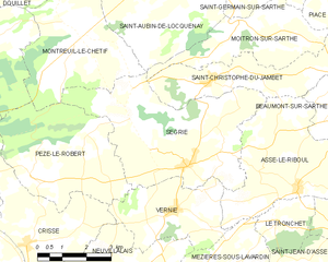
Montreuil-le-Chétif (Montreuil-le-Chétif)
- commune in Sarthe, France
- Country:

- Postal Code: 72130
- Coordinates: 48° 14' 43" N, 0° 2' 9" E


- GPS tracks (wikiloc): [Link]
- Area: 14.64 sq km
- Population: 302
- Web site: http://montreuil72.free.fr
- Wikipedia en: wiki(en)
- Wikipedia: wiki(fr)
- Wikidata storage: Wikidata: Q1227619
- Wikipedia Commons Category: [Link]
- Freebase ID: [/m/03qj07g]
- GeoNames ID: Alt: [6442631]
- SIREN number: [217202092]
- BnF ID: [15273764j]
- INSEE municipality code: 72209
Shares border with regions:
Douillet
- commune in France
- Country:

- Postal Code: 72130
- Coordinates: 48° 16' 23" N, 0° 2' 33" E


- GPS tracks (wikiloc): [Link]
- AboveSeaLevel: 110 м m
- Area: 18.99 sq km
- Population: 337


Pezé-le-Robert
- commune in Sarthe, France
- Country:

- Postal Code: 72140
- Coordinates: 48° 11' 37" N, 0° 3' 31" E


- GPS tracks (wikiloc): [Link]
- Area: 16.35 sq km
- Population: 370
Mont-Saint-Jean
- commune in Sarthe, France
- Country:

- Postal Code: 72140
- Coordinates: 48° 14' 47" N, 0° 6' 27" E


- GPS tracks (wikiloc): [Link]
- Area: 42.31 sq km
- Population: 661


Ségrie
- commune in Sarthe, France
- Country:

- Postal Code: 72170
- Coordinates: 48° 12' 0" N, 0° 1' 33" E


- GPS tracks (wikiloc): [Link]
- Area: 21.99 sq km
- Population: 619
Saint-Aubin-de-Locquenay
- commune in Sarthe, France
- Country:

- Postal Code: 72130
- Coordinates: 48° 16' 12" N, 0° 1' 25" E


- GPS tracks (wikiloc): [Link]
- Area: 17.31 sq km
- Population: 675
