Morsan (Morsan)

- commune in Eure, France
- Country:

- Postal Code: 27800
- Coordinates: 49° 10' 55" N, 0° 35' 39" E


- GPS tracks (wikiloc): [Link]
- Area: 4.83 sq km
- Population: 115
- Wikipedia en: wiki(en)
- Wikipedia: wiki(fr)
- Wikidata storage: Wikidata: Q627239
- Wikipedia Commons Category: [Link]
- Freebase ID: [/m/03nqkfc]
- Freebase ID: [/m/03nqkfc]
- GeoNames ID: Alt: [2991720]
- GeoNames ID: Alt: [2991720]
- SIREN number: [212704183]
- SIREN number: [212704183]
- BnF ID: [152536536]
- BnF ID: [152536536]
- Trismegistos Geo ID: [31050]
- Trismegistos Geo ID: [31050]
- INSEE municipality code: 27418
- INSEE municipality code: 27418
Shares border with regions:


Neuville-sur-Authou
- commune in Eure, France
- Country:
- Postal Code: 27800
- Coordinates: 49° 12' 41" N, 0° 38' 14" E
- GPS tracks (wikiloc): [Link]
- Area: 5.54 sq km
- Population: 199

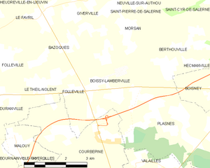
Boissy-Lamberville
- commune in Eure, France
- Country:
- Postal Code: 27300
- Coordinates: 49° 10' 2" N, 0° 34' 36" E
- GPS tracks (wikiloc): [Link]
- Area: 8.08 sq km
- Population: 335


Berthouville
- commune in Eure, France
- Country:
- Postal Code: 27800
- Coordinates: 49° 10' 46" N, 0° 38' 5" E
- GPS tracks (wikiloc): [Link]
- Area: 7.53 sq km
- Population: 306


Notre-Dame-d'Épine
- commune in Eure, France
- Country:
- Postal Code: 27800
- Coordinates: 49° 11' 50" N, 0° 36' 3" E
- GPS tracks (wikiloc): [Link]
- Area: 1.7 sq km
- Population: 80

Giverville
- commune in Eure, France
- Country:
- Postal Code: 27560
- Coordinates: 49° 11' 45" N, 0° 34' 9" E
- GPS tracks (wikiloc): [Link]
- Area: 6.14 sq km
- Population: 375