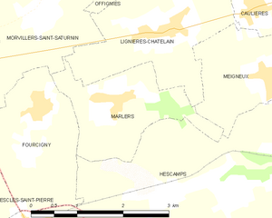
Morvillers-Saint-Saturnin (Morvillers-Saint-Saturnin)

- commune in Somme, France
- Country:

- Postal Code: 80590
- Coordinates: 49° 46' 50" N, 1° 49' 32" E


- GPS tracks (wikiloc): [Link]
- Area: 12.78 sq km
- Population: 411
- Wikipedia en: wiki(en)
- Wikipedia: wiki(fr)
- Wikidata storage: Wikidata: Q628650
- Wikipedia Commons Category: [Link]
- Freebase ID: [/m/03qm81f]
- GeoNames ID: Alt: [6444638]
- SIREN number: [218005403]
- BnF ID: [15277049p]
- PACTOLS thesaurus ID: [pcrtSd8MryRtPe]
- INSEE municipality code: 80573
Shares border with regions:


Quincampoix-Fleuzy
- commune in Oise, France
- Country:
- Postal Code: 60220
- Coordinates: 49° 44' 48" N, 1° 46' 21" E
- GPS tracks (wikiloc): [Link]
- Area: 9.22 sq km
- Population: 402
Escles-Saint-Pierre
- commune in Oise, France
- Country:
- Postal Code: 60220
- Coordinates: 49° 44' 28" N, 1° 48' 12" E
- GPS tracks (wikiloc): [Link]
- Area: 3.37 sq km
- Population: 158


Fourcigny
- commune in Somme, France
- Country:
- Postal Code: 80590
- Coordinates: 49° 45' 34" N, 1° 49' 32" E
- GPS tracks (wikiloc): [Link]
- Area: 4.55 sq km
- Population: 184


Gauville
- commune in Somme, France
- Country:
- Postal Code: 80290
- Coordinates: 49° 46' 53" N, 1° 47' 27" E
- GPS tracks (wikiloc): [Link]
- Area: 7.32 sq km
- Population: 355


Lafresguimont-Saint-Martin
- commune in Somme, France
- Country:
- Postal Code: 80430
- Coordinates: 49° 48' 55" N, 1° 48' 32" E
- GPS tracks (wikiloc): [Link]
- AboveSeaLevel: 185 м m
- Area: 26.54 sq km
- Population: 533

Marlers
- commune in Somme, France
- Country:
- Postal Code: 80590
- Coordinates: 49° 45' 41" N, 1° 50' 56" E
- GPS tracks (wikiloc): [Link]
- Area: 3.93 sq km
- Population: 139

Offignies
- commune in Somme, France
- Country:
- Postal Code: 80590
- Coordinates: 49° 47' 55" N, 1° 51' 7" E
- GPS tracks (wikiloc): [Link]
- Area: 4.47 sq km
- Population: 71


Aumale
- commune in Seine-Maritime, France
- Country:
- Postal Code: 76390
- Coordinates: 49° 46' 15" N, 1° 45' 7" E
- GPS tracks (wikiloc): [Link]
- Area: 9.06 sq km
- Population: 2177
- Web site: [Link]

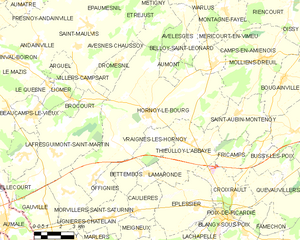
Hornoy-le-Bourg
- commune in Somme, France
- Country:
- Postal Code: 80640
- Coordinates: 49° 50' 44" N, 1° 54' 5" E
- GPS tracks (wikiloc): [Link]
- AboveSeaLevel: 166 м m
- Area: 51.23 sq km
- Population: 1662
- Web site: [Link]


Lignières-Châtelain
- commune in Somme, France
- Country:
- Postal Code: 80590
- Coordinates: 49° 46' 30" N, 1° 51' 47" E
- GPS tracks (wikiloc): [Link]
- Area: 6.54 sq km
- Population: 374
- Web site: [Link]