Moutiers (Moutiers)

- commune in Ille-et-Vilaine, France
- Country:

- Postal Code: 35130
- Coordinates: 47° 58' 2" N, 1° 12' 50" E


- GPS tracks (wikiloc): [Link]
- Area: 17.64 sq km
- Population: 941
- Web site: http://www.moutiers.bzh
- Wikipedia en: wiki(en)
- Wikipedia: wiki(fr)
- Wikidata storage: Wikidata: Q548818
- Wikipedia Commons Category: [Link]
- Freebase ID: [/m/03m9pjx]
- Freebase ID: [/m/03m9pjx]
- GeoNames ID: Alt: [6432772]
- GeoNames ID: Alt: [6432772]
- SIREN number: [213502008]
- SIREN number: [213502008]
- BnF ID: [15257143g]
- BnF ID: [15257143g]
- OSM relation ID: [139663]
- OSM relation ID: [139663]
- PACTOLS thesaurus ID: [pcrtzESw2JBjAk]
- PACTOLS thesaurus ID: [pcrtzESw2JBjAk]
- INSEE municipality code: 35200
- INSEE municipality code: 35200
Shares border with regions:


Gennes-sur-Seiche
- commune in Ille-et-Vilaine, France
- Country:
- Postal Code: 35370
- Coordinates: 47° 59' 17" N, 1° 7' 26" E
- GPS tracks (wikiloc): [Link]
- Area: 18.5 sq km
- Population: 930
- Web site: [Link]


Saint-Germain-du-Pinel
- commune in Ille-et-Vilaine, France
- Country:
- Postal Code: 35370
- Coordinates: 48° 0' 44" N, 1° 9' 58" E
- GPS tracks (wikiloc): [Link]
- Area: 11.3 sq km
- Population: 913


Availles-sur-Seiche
- commune in Ille-et-Vilaine, France
- Country:
- Postal Code: 35130
- Coordinates: 47° 57' 40" N, 1° 11' 45" E
- GPS tracks (wikiloc): [Link]
- Area: 11.06 sq km
- Population: 686

La Guerche-de-Bretagne
- commune in Ille-et-Vilaine, France
- Country:
- Postal Code: 35130
- Coordinates: 47° 56' 29" N, 1° 13' 47" E
- GPS tracks (wikiloc): [Link]
- Area: 11.53 sq km
- Population: 4281
- Web site: [Link]

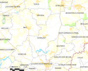
Domalain
- commune in Ille-et-Vilaine, France
- Country:
- Postal Code: 35680
- Coordinates: 47° 59' 46" N, 1° 14' 30" E
- GPS tracks (wikiloc): [Link]
- Area: 33.54 sq km
- Population: 1985