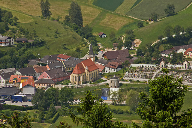
Nöchling (Nöchling)
- municipality in Austria
Nöchling is a beautiful area located in Austria, particularly in the region of Upper Austria. It is known for its stunning landscapes, with rolling hills, forests, and rivers, making it an excellent destination for hiking enthusiasts.
Hiking Trails:
-
Nöchling Summit Trail: This trail takes you to the summit of Nöchling, offering panoramic views of the surrounding area. The hike is moderately challenging, making it suitable for hikers with some experience.
-
Forest Trails: There are numerous forest trails that meander through the dense woodlands around Nöchling. These paths provide a serene setting, ideal for those looking to escape into nature.
-
River Walks: The region is often crisscrossed by rivers and streams. Trails along these waterways provide a unique perspective of the landscape and can be easier for families or less experienced hikers.
Tips for Hiking in Nöchling:
-
Check the Weather: The weather can change rapidly in mountainous areas, so it’s advisable to check the forecast before your hike.
-
Dress Appropriately: Wear layers and waterproof gear if necessary, and ensure you have sturdy hiking boots.
-
Stay Hydrated: Carry enough water, especially on longer hikes. There may not always be reliable sources of water on the trails.
-
Respect Nature: Stay on designated paths, and follow Leave No Trace principles to minimize your impact on the environment.
Best Time to Hike:
- Spring and Fall: These seasons typically offer pleasant temperatures and beautiful scenery, with wildflowers in bloom or autumn foliage.
Accessibility:
Make sure to check trail conditions and accessibility, particularly in winter or after heavy rains, as some paths may become slippery or washed out.
Local Resources:
Consider visiting the local tourism office or using local hiking apps for trail maps and additional information on guided hikes or organized events.
Overall, Nöchling offers a mix of natural beauty and outdoor activity, making it a great spot for both casual walkers and serious hikers alike!
- Country:

- Postal Code: 3691
- Local Dialing Code: 07414
- Licence Plate Code: ME
- Coordinates: 48° 13' 25" N, 14° 58' 58" E


- GPS tracks (wikiloc): [Link]
- AboveSeaLevel: 533 м m
- Area: 19.59 sq km
- Population: 1077
- Web site: http://www.noechling.at/
- Wikipedia en: wiki(en)
- Wikipedia: wiki(de)
- Wikidata storage: Wikidata: Q876348
- Wikipedia Commons Category: [Link]
- Freebase ID: [/m/02qydg5]
- GeoNames ID: Alt: [7872947]
- VIAF ID: Alt: [234326482]
- Austrian municipality key: [31528]
Shares border with regions:
Neustadtl an der Donau
- municipality in Austria
 Hiking in Neustadtl an der Donau
Neustadtl an der Donau is a charming town located in the Austrian state of Upper Austria, situated along the Danube River. Hiking in this area offers a blend of scenic views, historical landmarks, and lush countryside. Here are some key points to consider when hiking around Neustadtl an der Donau:...
- Country:

- Postal Code: 3323
- Local Dialing Code: 07471
- Licence Plate Code: AM
- Coordinates: 48° 11' 36" N, 14° 54' 10" E


- GPS tracks (wikiloc): [Link]
- AboveSeaLevel: 507 м m
- Area: 47.89 sq km
- Population: 2143
- Web site: [Link]

Sankt Nikola an der Donau
- municipality in Austria
 Hiking in Sankt Nikola an der Donau
Sankt Nikola an der Donau is a picturesque village located along the Danube River in Austria, surrounded by natural beauty and historical sites, making it a great destination for hiking enthusiasts. Here are some highlights for hiking in the area:...
- Country:

- Postal Code: 4381
- Local Dialing Code: 07268
- Licence Plate Code: PE
- Coordinates: 48° 14' 0" N, 14° 54' 24" E


- GPS tracks (wikiloc): [Link]
- AboveSeaLevel: 249 м m
- Area: 13.18 sq km
- Population: 798
- Web site: [Link]
Sankt Oswald, Lower Austria
- municipality in Austria
 Hiking in Sankt Oswald, Lower Austria
Sankt Oswald in Lower Austria is a beautiful area for hiking, offering a mix of lush forests, rolling hills, and serene landscapes. Here are some highlights and details about hiking in this region:...
- Country:

- Postal Code: 3684
- Local Dialing Code: 07415
- Licence Plate Code: ME
- Coordinates: 48° 16' 0" N, 15° 2' 10" E


- GPS tracks (wikiloc): [Link]
- AboveSeaLevel: 658 м m
- Area: 32.15 sq km
- Population: 1124
- Web site: [Link]
Hofamt Priel
- municipality in Austria
Hofamt Priel is a picturesque area in the Lower Austria region of Austria, known for its beautiful landscapes and hiking opportunities. Nestled at the foothills of the Alps, the area offers a variety of trails suitable for different skill levels, from casual walkers to experienced hikers....
- Country:

- Postal Code: 3681
- Local Dialing Code: 07412
- Licence Plate Code: ME
- Coordinates: 48° 11' 50" N, 15° 4' 30" E


- GPS tracks (wikiloc): [Link]
- AboveSeaLevel: 240 м m
- Area: 39.63 sq km
- Population: 1675
- Web site: [Link]

Waldhausen im Strudengau
- municipality in Austria
 Hiking in Waldhausen im Strudengau
Waldhausen im Strudengau is a picturesque village located in the heart of the Strudengau region of Austria, surrounded by the stunning landscape of the Danube River and the rolling hills of the Bohemian Forest. Hiking in this area offers a unique blend of natural beauty, historical sites, and cultural experiences....
- Country:

- Postal Code: 4391
- Local Dialing Code: 07260
- Licence Plate Code: PE
- Coordinates: 48° 16' 39" N, 14° 57' 0" E


- GPS tracks (wikiloc): [Link]
- AboveSeaLevel: 470 м m
- Area: 46.85 sq km
- Population: 2870
- Web site: [Link]