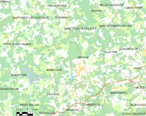
Pérols-sur-Vézère (Pérols-sur-Vézère)

- commune in Corrèze, France
- Country:

- Postal Code: 19170
- Coordinates: 45° 35' 10" N, 1° 58' 47" E


- GPS tracks (wikiloc): [Link]
- Area: 46.98 sq km
- Population: 178
- Web site: http://www.perols-sur-vezere.fr
- Wikipedia en: wiki(en)
- Wikipedia: wiki(fr)
- Wikidata storage: Wikidata: Q624461
- Wikipedia Commons Category: [Link]
- Freebase ID: [/m/03mfbcb]
- GeoNames ID: Alt: [2987933]
- SIREN number: [211916002]
- BnF ID: [152497960]
- PACTOLS thesaurus ID: [pcrt4YaUccN5AA]
- INSEE municipality code: 19160
Shares border with regions:


Saint-Merd-les-Oussines
- commune in Corrèze, France
- Country:
- Postal Code: 19170
- Coordinates: 45° 37' 57" N, 2° 2' 24" E
- GPS tracks (wikiloc): [Link]
- Area: 42.46 sq km
- Population: 130

Meymac
- commune in Corrèze, France
- Country:
- Postal Code: 19250
- Coordinates: 45° 32' 9" N, 2° 8' 49" E
- GPS tracks (wikiloc): [Link]
- Area: 87.15 sq km
- Population: 2455

Ambrugeat
- commune in Corrèze, France
- Country:
- Postal Code: 19250
- Coordinates: 45° 31' 36" N, 2° 7' 4" E
- GPS tracks (wikiloc): [Link]
- Area: 29.57 sq km
- Population: 197

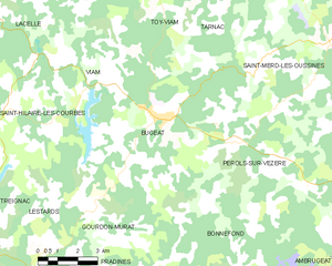
Bugeat
- commune in Corrèze, France
- Country:
- Postal Code: 19170
- Coordinates: 45° 35' 53" N, 1° 55' 38" E
- GPS tracks (wikiloc): [Link]
- Area: 30.99 sq km
- Population: 829


Bonnefond
- commune in Corrèze, France
- Country:
- Postal Code: 19170
- Coordinates: 45° 31' 54" N, 1° 59' 1" E
- GPS tracks (wikiloc): [Link]
- Area: 45.06 sq km
- Population: 113