Parcoul (Parcoul)

- former commune in Dordogne, France
- Country:

- Postal Code: 24410
- Coordinates: 45° 12' 18" N, 0° 2' 8" E


- GPS tracks (wikiloc): [Link]
- Area: 14.17 sq km
- Population: 422
- Wikipedia en: wiki(en)
- Wikipedia: wiki(fr)
- Wikidata storage: Wikidata: Q1078767
- Wikipedia Commons Category: [Link]
- Freebase ID: [/m/03mg7d3]
- Freebase ID: [/m/03mg7d3]
- GeoNames ID: Alt: [2988567]
- GeoNames ID: Alt: [2988567]
- BnF ID: [15251962h]
- BnF ID: [15251962h]
- VIAF ID: Alt: [236160521]
- VIAF ID: Alt: [236160521]
- INSEE municipality code: 24316
- INSEE municipality code: 24316
Shares border with regions:

Saint-Aigulin
- commune in Charente-Maritime, France
- Country:
- Postal Code: 17360
- Coordinates: 45° 9' 25" N, 0° 0' 37" E
- GPS tracks (wikiloc): [Link]
- Area: 28.36 sq km
- Population: 1895
- Web site: [Link]


Bazac
- commune in Charente, France
- Country:
- Postal Code: 16210
- Coordinates: 45° 13' 52" N, 0° 2' 58" E
- GPS tracks (wikiloc): [Link]
- Area: 4.92 sq km
- Population: 149

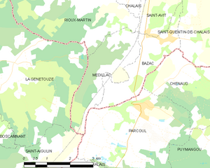
Médillac
- commune in Charente, France
- Country:
- Postal Code: 16210
- Coordinates: 45° 13' 20" N, 0° 1' 26" E
- GPS tracks (wikiloc): [Link]
- Area: 5.84 sq km
- Population: 158