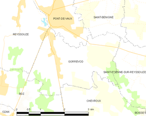
Pont-de-Vaux (Pont-de-Vaux)
- commune in Ain, France
- Country:

- Postal Code: 01190
- Coordinates: 46° 25' 55" N, 4° 56' 17" E


- GPS tracks (wikiloc): [Link]
- Area: 7.54 sq km
- Population: 2296
- Web site: http://www.pontdevaux.com
- Wikipedia en: wiki(en)
- Wikipedia: wiki(fr)
- Wikidata storage: Wikidata: Q840893
- Wikipedia Commons Category: [Link]
- Wikipedia Commons Maps Category: [Link]
- Freebase ID: [/m/081n3y]
- Freebase ID: [/m/081n3y]
- GeoNames ID: Alt: [6424630]
- GeoNames ID: Alt: [6424630]
- SIREN number: [210103057]
- SIREN number: [210103057]
- BnF ID: [120030396]
- BnF ID: [120030396]
- VIAF ID: Alt: [147927557]
- VIAF ID: Alt: [147927557]
- Library of Congress authority ID: Alt: [n98029416]
- Library of Congress authority ID: Alt: [n98029416]
- MusicBrainz area ID: [f9a0a3fa-6e8e-454d-ac3f-d3e1a05b1fca]
- MusicBrainz area ID: [f9a0a3fa-6e8e-454d-ac3f-d3e1a05b1fca]
- INSEE municipality code: 01305
- INSEE municipality code: 01305
Shares border with regions:

Reyssouze
- commune in Ain, France
- Country:
- Postal Code: 01190
- Coordinates: 46° 25' 55" N, 4° 55' 9" E
- GPS tracks (wikiloc): [Link]
- Area: 9.54 sq km
- Population: 970

Saint-Bénigne
- commune in Ain, France
- Country:
- Postal Code: 01190
- Coordinates: 46° 26' 41" N, 4° 57' 38" E
- GPS tracks (wikiloc): [Link]
- Area: 16.49 sq km
- Population: 1242

Gorrevod
- commune in Ain, France
- Country:
- Postal Code: 01190
- Coordinates: 46° 24' 57" N, 4° 56' 28" E
- GPS tracks (wikiloc): [Link]
- Area: 6.88 sq km
- Population: 854

Montbellet
- commune in Saône-et-Loire, France
- Country:
- Postal Code: 71260
- Coordinates: 46° 28' 31" N, 4° 52' 19" E
- GPS tracks (wikiloc): [Link]
- Area: 19.78 sq km
- Population: 801
- Web site: [Link]


Fleurville
- commune in Saône-et-Loire, France
- Country:
- Postal Code: 71260
- Coordinates: 46° 26' 41" N, 4° 52' 50" E
- GPS tracks (wikiloc): [Link]
- Area: 3.91 sq km
- Population: 506
- Web site: [Link]