Pontaumur (Pontaumur)

- commune in Puy-de-Dôme, France
- Country:

- Postal Code: 63380
- Coordinates: 45° 52' 7" N, 2° 40' 29" E


- GPS tracks (wikiloc): [Link]
- Area: 13.81 sq km
- Population: 672
- Web site: http://63283.campagnol.fr
- Wikipedia en: wiki(en)
- Wikipedia: wiki(fr)
- Wikidata storage: Wikidata: Q774831
- Wikipedia Commons Category: [Link]
- Freebase ID: [/m/03ql100]
- GeoNames ID: Alt: [6440137]
- SIREN number: [216302836]
- BnF ID: [152696337]
- INSEE municipality code: 63283
Shares border with regions:

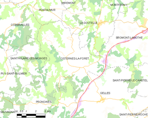
Cisternes-la-Forêt
- commune in Puy-de-Dôme, France
- Country:
- Postal Code: 63740
- Coordinates: 45° 47' 25" N, 2° 42' 18" E
- GPS tracks (wikiloc): [Link]
- Area: 33.58 sq km
- Population: 472

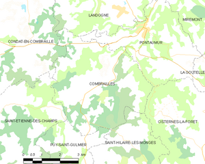
Combrailles
- commune in Puy-de-Dôme, France
- Country:
- Postal Code: 63380
- Coordinates: 45° 50' 26" N, 2° 37' 56" E
- GPS tracks (wikiloc): [Link]
- Area: 20.61 sq km
- Population: 219


Miremont
- commune in Puy-de-Dôme, France
- Country:
- Postal Code: 63380
- Coordinates: 45° 53' 55" N, 2° 43' 1" E
- GPS tracks (wikiloc): [Link]
- Area: 36.79 sq km
- Population: 302

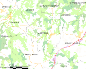
La Goutelle
- commune in Puy-de-Dôme, France
- Country:
- Postal Code: 63230
- Coordinates: 45° 50' 29" N, 2° 45' 31" E
- GPS tracks (wikiloc): [Link]
- Area: 24.25 sq km
- Population: 621
- Web site: [Link]
Landogne
- commune in Puy-de-Dôme, France
- Country:
- Postal Code: 63380
- Coordinates: 45° 52' 39" N, 2° 39' 23" E
- GPS tracks (wikiloc): [Link]
- Area: 17.37 sq km
- Population: 242
- Web site: [Link]