Pontgibaud (Pontgibaud)

- commune in Puy-de-Dôme, France
- Country:

- Postal Code: 63230
- Coordinates: 45° 49' 57" N, 2° 51' 3" E


- GPS tracks (wikiloc): [Link]
- Area: 4.59 sq km
- Population: 738
- Web site: http://www.ville-pontgibaud.fr
- Wikipedia en: wiki(en)
- Wikipedia: wiki(fr)
- Wikidata storage: Wikidata: Q284445
- Wikipedia Commons Gallery: [Link]
- Wikipedia Commons Category: [Link]
- Freebase ID: [/m/02r06zk]
- GeoNames ID: Alt: [6440139]
- SIREN number: [216302851]
- BnF ID: [15269635x]
- VIAF ID: Alt: [246684898]
- WOEID: [617449]
- INSEE municipality code: 63285
Shares border with regions:


Bromont-Lamothe
- commune in Puy-de-Dôme, France
- Country:
- Postal Code: 63230
- Coordinates: 45° 50' 25" N, 2° 49' 9" E
- GPS tracks (wikiloc): [Link]
- Area: 38.07 sq km
- Population: 988

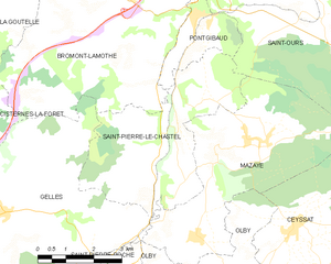
Saint-Pierre-le-Chastel
- commune in Puy-de-Dôme, France
- Country:
- Postal Code: 63230
- Coordinates: 45° 47' 54" N, 2° 50' 35" E
- GPS tracks (wikiloc): [Link]
- Area: 17.45 sq km
- Population: 425

Saint-Ours
- commune in Puy-de-Dôme, France
- Country:
- Postal Code: 63230
- Coordinates: 45° 51' 1" N, 2° 53' 30" E
- GPS tracks (wikiloc): [Link]
- Area: 55.64 sq km
- Population: 1675
- Web site: [Link]