Prin-Deyrançon (Prin-Deyrançon)

- commune in Deux-Sèvres, France
- Country:

- Postal Code: 79210
- Coordinates: 46° 13' 18" N, 0° 38' 11" E


- GPS tracks (wikiloc): [Link]
- Area: 16.12 sq km
- Population: 616
- Wikipedia en: wiki(en)
- Wikipedia: wiki(fr)
- Wikidata storage: Wikidata: Q1148868
- Wikipedia Commons Category: [Link]
- Freebase ID: [/m/03mg3lf]
- GeoNames ID: Alt: [2985306]
- SIREN number: [217902204]
- BnF ID: [152763556]
- INSEE municipality code: 79220
Shares border with regions:
Le Bourdet
- commune in Deux-Sèvres, France
- Country:
- Postal Code: 79210
- Coordinates: 46° 14' 0" N, 0° 37' 21" E
- GPS tracks (wikiloc): [Link]
- Area: 8.3 sq km
- Population: 588


Cramchaban
- commune in Charente-Maritime, France
- Country:
- Postal Code: 17170
- Coordinates: 46° 13' 10" N, 0° 43' 19" E
- GPS tracks (wikiloc): [Link]
- Area: 16.06 sq km
- Population: 654
Épannes
- commune in Deux-Sèvres, France
- Country:
- Postal Code: 79270
- Coordinates: 46° 13' 50" N, 0° 35' 2" E
- GPS tracks (wikiloc): [Link]
- Area: 8.01 sq km
- Population: 852
- Web site: [Link]

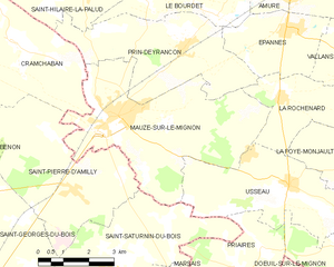
Mauzé-sur-le-Mignon
- commune in Deux-Sèvres, France
- Country:
- Postal Code: 79210
- Coordinates: 46° 11' 43" N, 0° 40' 16" E
- GPS tracks (wikiloc): [Link]
- Area: 23.62 sq km
- Population: 2767
Saint-Hilaire-la-Palud
- commune in Deux-Sèvres, France
- Country:
- Postal Code: 79210
- Coordinates: 46° 15' 48" N, 0° 42' 44" E
- GPS tracks (wikiloc): [Link]
- Area: 34.12 sq km
- Population: 1575
- Web site: [Link]

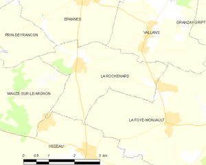
La Rochénard
- commune in Deux-Sèvres, France
- Country:
- Postal Code: 79270
- Coordinates: 46° 12' 20" N, 0° 35' 11" E
- GPS tracks (wikiloc): [Link]
- Area: 8.55 sq km
- Population: 580