Romilly-la-Puthenaye (Romilly-la-Puthenaye)

- commune in Eure, France
- Country:

- Postal Code: 27170
- Coordinates: 49° 0' 8" N, 0° 50' 51" E


- GPS tracks (wikiloc): [Link]
- Area: 11.85 sq km
- Population: 320
- Wikipedia en: wiki(en)
- Wikipedia: wiki(fr)
- Wikidata storage: Wikidata: Q1072947
- Wikipedia Commons Category: [Link]
- Freebase ID: [/m/03nqlb7]
- Freebase ID: [/m/03nqlb7]
- GeoNames ID: Alt: [6430545]
- GeoNames ID: Alt: [6430545]
- SIREN number: [212704928]
- SIREN number: [212704928]
- BnF ID: [15253727x]
- BnF ID: [15253727x]
- INSEE municipality code: 27492
- INSEE municipality code: 27492
Shares border with regions:

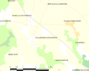
Collandres-Quincarnon
- commune in Eure, France
- Country:
- Postal Code: 27190
- Coordinates: 48° 59' 46" N, 0° 51' 9" E
- GPS tracks (wikiloc): [Link]
- Area: 7.98 sq km
- Population: 219


Barquet
- commune in Eure, France
- Country:
- Postal Code: 27170
- Coordinates: 49° 2' 46" N, 0° 51' 31" E
- GPS tracks (wikiloc): [Link]
- Area: 13.68 sq km
- Population: 442

Berville-la-Campagne
- commune in Eure, France
- Country:
- Postal Code: 27170
- Coordinates: 49° 1' 35" N, 0° 54' 3" E
- GPS tracks (wikiloc): [Link]
- Area: 8.68 sq km
- Population: 240


La Houssaye
- commune in Eure, France
- Country:
- Postal Code: 27410
- Coordinates: 48° 59' 35" N, 0° 48' 1" E
- GPS tracks (wikiloc): [Link]
- Area: 4.25 sq km
- Population: 212


Grosley-sur-Risle
- commune in Eure, France
- Country:
- Postal Code: 27170
- Coordinates: 49° 3' 0" N, 0° 48' 46" E
- GPS tracks (wikiloc): [Link]
- Area: 13.18 sq km
- Population: 525