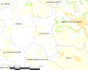
Rosnay (Rosnay)

- commune in Vendée, France
- Country:

- Postal Code: 85320
- Coordinates: 46° 32' 23" N, 1° 18' 31" E


- GPS tracks (wikiloc): [Link]
- Area: 14.11 sq km
- Population: 610
- Wikipedia en: wiki(en)
- Wikipedia: wiki(fr)
- Wikidata storage: Wikidata: Q1420412
- Wikipedia Commons Category: [Link]
- Freebase ID: [/m/03wck4n]
- SIREN number: [218501930]
- BnF ID: [152783174]
- PACTOLS thesaurus ID: [pcrtQA6cOns9wo]
- INSEE municipality code: 85193
Shares border with regions:

La Bretonnière-la-Claye
- commune in Vendée, France
- Country:
- Postal Code: 85320
- Coordinates: 46° 28' 59" N, 1° 15' 22" E
- GPS tracks (wikiloc): [Link]
- Area: 16.48 sq km
- Population: 589


Le Champ-Saint-Père
- commune in Vendée, France
- Country:
- Postal Code: 85540
- Coordinates: 46° 30' 30" N, 1° 20' 48" E
- GPS tracks (wikiloc): [Link]
- Area: 24.67 sq km
- Population: 1840
- Web site: [Link]

Château-Guibert
- commune in Vendée, France
- Country:
- Postal Code: 85320
- Coordinates: 46° 34' 54" N, 1° 14' 10" E
- GPS tracks (wikiloc): [Link]
- Area: 35.16 sq km
- Population: 1553
- Web site: [Link]


Le Tablier
- commune in Vendée, France
- Country:
- Postal Code: 85310
- Coordinates: 46° 34' 29" N, 1° 20' 37" E
- GPS tracks (wikiloc): [Link]
- AboveSeaLevel: 40 м m
- Area: 9.28 sq km
- Population: 749
- Web site: [Link]

La Couture
- commune in Vendée, France
- Country:
- Postal Code: 85320
- Coordinates: 46° 31' 15" N, 1° 15' 50" E
- GPS tracks (wikiloc): [Link]
- Area: 7.03 sq km
- Population: 214
- Web site: [Link]

Mareuil-sur-Lay-Dissais
- commune in Vendée, France
- Country:
- Postal Code: 85320
- Coordinates: 46° 32' 4" N, 1° 13' 4" E
- GPS tracks (wikiloc): [Link]
- AboveSeaLevel: 23 м m
- Area: 25.65 sq km
- Population: 2806
- Web site: [Link]

Chaillé-sous-les-Ormeaux
- former commune in Vendée, France
- Country:
- Postal Code: 85310
- Coordinates: 46° 35' 0" N, 1° 22' 7" E
- GPS tracks (wikiloc): [Link]
- AboveSeaLevel: 60 м m
- Area: 17.5 sq km
- Population: 1335
- Web site: [Link]