Saint-Alban-de-Roche (Saint-Alban-de-Roche)

- commune in Isère, France
 Hiking in Saint-Alban-de-Roche
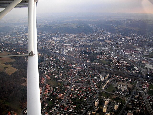
Saint-Alban-de-Roche is a charming commune located in the Auvergne-Rhône-Alpes region of France, near the city of Bourgoin-Jallieu. The area is characterized by its beautiful landscapes and a mix of rural and suburban environments, making it an attractive destination for hiking enthusiasts.
Hiking Opportunities:
-
Scenic Trails: The region offers a variety of hiking trails that range from easy walks to more challenging routes. The trails often provide stunning views of the surrounding countryside, including picturesque vineyards and rolling hills.
-
Natural Parks: Saint-Alban-de-Roche is close to several natural parks, such as the Chartreuse Regional Natural Park and the Pilat Regional Natural Park. These areas offer well-marked trails with diverse flora and fauna, making for a fulfilling hiking experience.
-
Local Flora and Fauna: The trails in and around Saint-Alban-de-Roche are home to a variety of plant and animal species. Birdwatching can also be enjoyed in certain areas, as the region attracts a range of bird species.
-
Cultural and Historical Sites: While hiking, you may encounter various historical landmarks. Exploring these sites can add an additional layer of interest to your hike.
-
Accessibility: The area’s proximity to major cities like Lyon makes it accessible for day trips or weekend getaways for hiking.
Tips for Hiking in Saint-Alban-de-Roche:
- Trail Maps: Always carry a trail map or GPS device as some paths may not be well-marked.
- Weather Preparedness: Check the weather forecast before you head out and dress appropriately. The weather can change rapidly in the mountains.
- Hydration and Snacks: Bring plenty of water and snacks to keep your energy levels up during your hike.
- Wildlife Awareness: Be mindful of local wildlife and practice Leave No Trace principles to preserve the environment.
Conclusion:
Hiking in Saint-Alban-de-Roche offers a delightful combination of natural beauty and cultural experiences. Whether you're looking for a leisurely stroll or a more vigorous hike, you'll find trails that cater to various skill levels, making it an excellent destination for all types of hikers. Enjoy your trek!
- Country:

- Postal Code: 38300
- Coordinates: 45° 35' 46" N, 5° 13' 27" E


- GPS tracks (wikiloc): [Link]
- Area: 6.11 sq km
- Population: 1905
- Web site: http://www.saintalbanderoche.com
- Wikipedia en: wiki(en)
- Wikipedia: wiki(fr)
- Wikidata storage: Wikidata: Q1067974
- Wikipedia Commons Category: [Link]
- Freebase ID: [/m/03nvj2d]
- GeoNames ID: Alt: [6433316]
- SIREN number: [213803521]
- BnF ID: [15258163b]
- VIAF ID: Alt: [240533043]
- INSEE municipality code: 38352
Shares border with regions:


Domarin
- commune in Isère, France
Hiking in Domarin
Domarin is a small town located in Slovenia, surrounded by stunning natural landscapes ideal for hiking enthusiasts. The area offers a variety of trails suitable for different skill levels, making it a great destination for both beginners and experienced hikers....
- Country:
- Postal Code: 38300
- Coordinates: 45° 35' 8" N, 5° 14' 39" E
- GPS tracks (wikiloc): [Link]
- Area: 2.99 sq km
- Population: 1556
- Web site: [Link]


L'Isle-d'Abeau
- commune in Isère, France
Hiking in L'Isle-d'Abeau
L'Isle-d'Abeau, located in the Auvergne-Rhône-Alpes region of France, is surrounded by a variety of landscapes that offer several hiking opportunities. While the town itself is primarily urban and industrial, its location makes it a convenient starting point for exploring nearby natural areas....
- Country:
- Postal Code: 38080
- Coordinates: 45° 37' 10" N, 5° 13' 59" E
- GPS tracks (wikiloc): [Link]
- Area: 9.11 sq km
- Population: 16282

Bourgoin-Jallieu
- commune in Isère, France
Hiking in Bourgoin-Jallieu
Bourgoin-Jallieu, located in the Auvergne-Rhône-Alpes region of eastern France, offers a variety of hiking opportunities for outdoor enthusiasts. The town is nestled between the Isère River and the Chartreuse Mountains, providing both flat terrain and more challenging trails....
- Country:
- Postal Code: 38300
- Coordinates: 45° 35' 27" N, 5° 16' 45" E
- GPS tracks (wikiloc): [Link]
- AboveSeaLevel: 254 м m
- Area: 24.37 sq km
- Population: 27502
- Web site: [Link]

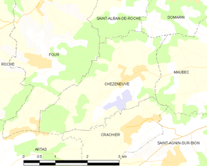
Chèzeneuve
- commune in Isère, France
Hiking in Chèzeneuve
Chèzeneuve is a charming area located in the Auvergne-Rhône-Alpes region of France, known for its beautiful landscapes, rolling hills, and outdoor activities, including hiking. The region provides a range of hiking trails suitable for various skill levels, from gentle strolls to more challenging treks....
- Country:
- Postal Code: 38300
- Coordinates: 45° 33' 44" N, 5° 13' 24" E
- GPS tracks (wikiloc): [Link]
- Area: 6.79 sq km
- Population: 550


Four
- commune in Isère, France
Hiking in Four
Four is a small village in the Isère department in the Auvergne-Rhône-Alpes region of southeastern France. While it may not be as well known as some of its neighboring areas, it provides a great opportunity for hiking enthusiasts to explore the beautiful scenery of the French Alps....
- Country:
- Postal Code: 38080
- Coordinates: 45° 35' 14" N, 5° 11' 44" E
- GPS tracks (wikiloc): [Link]
- Area: 11.82 sq km
- Population: 1434
- Web site: [Link]